You are here: Home > Network List > IU - Global Seismograph Network (GSN - IRIS/USGS) Stations List
> Station WVT Waverly, Tennessee, USA > Earthquake Result Viewer
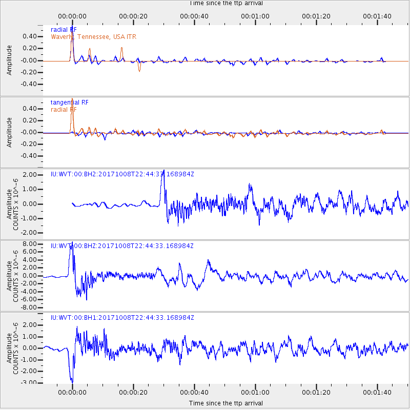
WVT Waverly, Tennessee, USA - Earthquake Result Viewer

| Earthquake location: |
Rat Islands, Aleutian Islands |
| Earthquake latitude/longitude: |
52.4/176.8 |
| Earthquake time(UTC): |
2017/10/08 (281) 22:34:33 GMT |
| Earthquake Depth: |
112 km |
| Earthquake Magnitude: |
6.6 mww |
| Earthquake Catalog/Contributor: |
NEIC PDE/us |
|
| Network: |
IU Global Seismograph Network (GSN - IRIS/USGS) |
| Station: |
WVT Waverly, Tennessee, USA |
| Lat/Lon: |
36.13 N/87.83 W |
| Elevation: |
170 m |
|
| Distance: |
65.3 deg |
| Az: |
62.527 deg |
| Baz: |
317.876 deg |
| Ray Param: |
0.058061697 |
| Estimated Moho Depth: |
55.25 km |
| Estimated Crust Vp/Vs: |
1.61 |
| Assumed Crust Vp: |
6.444 km/s |
| Estimated Crust Vs: |
3.996 km/s |
| Estimated Crust Poisson's Ratio: |
0.19 |
|
| Radial Match: |
94.9935 % |
| Radial Bump: |
277 |
| Transverse Match: |
80.45927 % |
| Transverse Bump: |
400 |
| SOD ConfigId: |
2364251 |
| Insert Time: |
2017-10-22 22:45:19.080 +0000 |
| GWidth: |
2.5 |
| Max Bumps: |
400 |
| Tol: |
0.001 |
|
Signal To Noise
| Channel | StoN | STA | LTA |
| IU:WVT:00:BHZ:20171008T22:44:33.168984Z | 41.88087 | 4.442331E-6 | 1.06070644E-7 |
| IU:WVT:00:BH1:20171008T22:44:33.168984Z | 11.300739 | 1.4420931E-6 | 1.276105E-7 |
| IU:WVT:00:BH2:20171008T22:44:33.168984Z | 9.9359865 | 1.0950993E-6 | 1.1021545E-7 |
| Arrivals |
| Ps | 5.5 SECOND |
| PpPs | 21 SECOND |
| PsPs/PpSs | 27 SECOND |


