You are here: Home > Network List > CI - Caltech Regional Seismic Network Stations List
> Station BAR Barrett, Tecate, CA, USA > Earthquake Result Viewer
BAR Barrett, Tecate, CA, USA - Earthquake Result Viewer
| Earthquake location: |
Southeast Of Loyalty Islands |
| Earthquake latitude/longitude: |
-23.1/171.6 |
| Earthquake time(UTC): |
2021/02/10 (041) 13:19:55 GMT |
| Earthquake Depth: |
10 km |
| Earthquake Magnitude: |
7.7 mww |
| Earthquake Catalog/Contributor: |
NEIC PDE/us |
|
| Network: |
CI Caltech Regional Seismic Network |
| Station: |
BAR Barrett, Tecate, CA, USA |
| Lat/Lon: |
32.68 N/116.67 W |
| Elevation: |
521 m |
|
| Distance: |
88.0 deg |
| Az: |
53.253 deg |
| Baz: |
241.062 deg |
| Ray Param: |
0.042889968 |
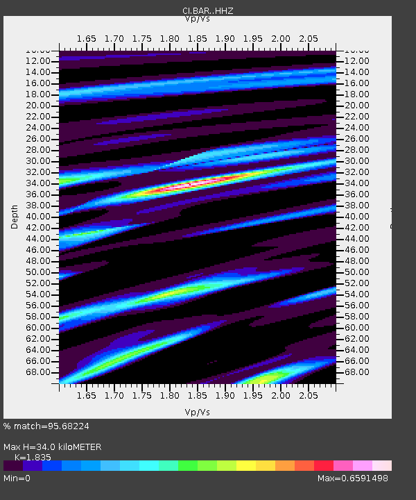
| Estimated Moho Depth: |
34.0 km |
| Estimated Crust Vp/Vs: |
1.84 |
| Assumed Crust Vp: |
6.264 km/s |
| Estimated Crust Vs: |
3.413 km/s |
| Estimated Crust Poisson's Ratio: |
0.29 |
|
| Radial Match: |
95.68224 % |
| Radial Bump: |
400 |
| Transverse Match: |
86.04723 % |
| Transverse Bump: |
400 |
| SOD ConfigId: |
23341671 |
| Insert Time: |
2021-02-24 14:26:12.002 +0000 |
| GWidth: |
2.5 |
| Max Bumps: |
400 |
| Tol: |
0.001 |
|
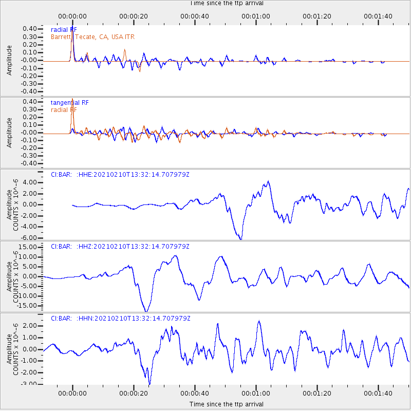
Signal To Noise
| Channel | StoN | STA | LTA |
| CI:BAR: :HHZ:20210210T13:32:14.707979Z | 2.0536659 | 6.84039E-7 | 3.3308194E-7 |
| CI:BAR: :HHN:20210210T13:32:14.707979Z | 1.2040762 | 3.1984618E-7 | 2.6563615E-7 |
| CI:BAR: :HHE:20210210T13:32:14.707979Z | 1.4789371 | 3.4145071E-7 | 2.3087576E-7 |
| Arrivals |
| Ps | 4.6 SECOND |
| PpPs | 15 SECOND |
| PsPs/PpSs | 20 SECOND |


