You are here: Home > Network List > GE - GEOFON Stations List
> Station WLF GEOFON Station Walferdange, Luxembourg > Earthquake Result Viewer
WLF GEOFON Station Walferdange, Luxembourg - Earthquake Result Viewer
| Earthquake location: |
East Of Kuril Islands |
| Earthquake latitude/longitude: |
44.7/150.2 |
| Earthquake time(UTC): |
1994/08/18 (230) 04:42:59 GMT |
| Earthquake Depth: |
33 km |
| Earthquake Magnitude: |
6.1 MB, 6.5 MS, 6.6 UNKNOWN, 6.5 MW |
| Earthquake Catalog/Contributor: |
WHDF/NEIC |
|
| Network: |
GE GEOFON |
| Station: |
WLF GEOFON Station Walferdange, Luxembourg |
| Lat/Lon: |
49.66 N/6.15 E |
| Elevation: |
295 m |
|
| Distance: |
80.9 deg |
| Az: |
337.259 deg |
| Baz: |
25.117 deg |
| Ray Param: |
0.04788918 |
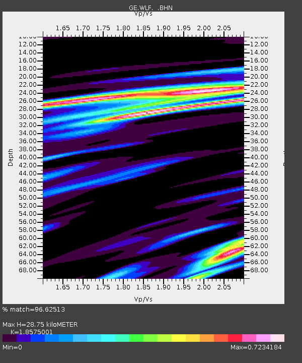
| Estimated Moho Depth: |
28.75 km |
| Estimated Crust Vp/Vs: |
1.86 |
| Assumed Crust Vp: |
6.182 km/s |
| Estimated Crust Vs: |
3.328 km/s |
| Estimated Crust Poisson's Ratio: |
0.30 |
|
| Radial Match: |
96.62513 % |
| Radial Bump: |
265 |
| Transverse Match: |
88.10808 % |
| Transverse Bump: |
400 |
| SOD ConfigId: |
17000 |
| Insert Time: |
2010-03-09 05:16:25.207 +0000 |
| GWidth: |
2.5 |
| Max Bumps: |
400 |
| Tol: |
0.001 |
|

Signal To Noise
| Channel | StoN | STA | LTA |
| GE:WLF: :BHN:19940818T04:54:39.553003Z | 8.515878 | 1.0728543E-6 | 1.2598281E-7 |
| GE:WLF: :BHE:19940818T04:54:39.552026Z | 4.8159966 | 5.2965896E-7 | 1.0997909E-7 |
| GE:WLF: :BHZ:19940818T04:54:39.553003Z | 28.593264 | 2.8945562E-6 | 1.0123211E-7 |
| Arrivals |
| Ps | 4.1 SECOND |
| PpPs | 13 SECOND |
| PsPs/PpSs | 17 SECOND |


