You are here: Home > Network List > CN - Canadian National Seismograph Network Stations List
> Station BPEB Brooks Peninsula, BC, CA > Earthquake Result Viewer
BPEB Brooks Peninsula, BC, CA - Earthquake Result Viewer
| Earthquake location: |
Southeast Of Loyalty Islands |
| Earthquake latitude/longitude: |
-23.1/171.6 |
| Earthquake time(UTC): |
2021/02/10 (041) 13:19:55 GMT |
| Earthquake Depth: |
10 km |
| Earthquake Magnitude: |
7.7 mww |
| Earthquake Catalog/Contributor: |
NEIC PDE/us |
|
| Network: |
CN Canadian National Seismograph Network |
| Station: |
BPEB Brooks Peninsula, BC, CA |
| Lat/Lon: |
50.16 N/127.77 W |
| Elevation: |
737 m |
|
| Distance: |
90.4 deg |
| Az: |
34.094 deg |
| Baz: |
233.388 deg |
| Ray Param: |
0.041704252 |
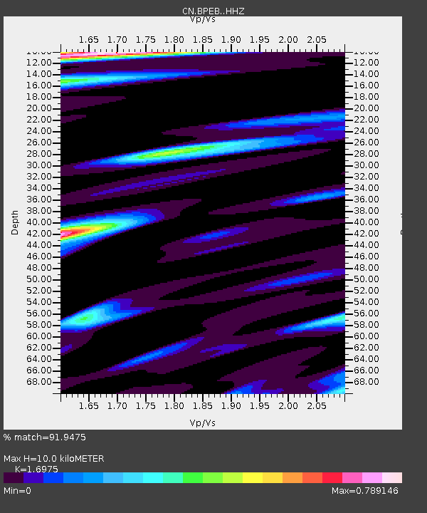
| Estimated Moho Depth: |
10.0 km |
| Estimated Crust Vp/Vs: |
1.70 |
| Assumed Crust Vp: |
6.545 km/s |
| Estimated Crust Vs: |
3.856 km/s |
| Estimated Crust Poisson's Ratio: |
0.23 |
|
| Radial Match: |
91.9475 % |
| Radial Bump: |
400 |
| Transverse Match: |
72.95467 % |
| Transverse Bump: |
400 |
| SOD ConfigId: |
23341671 |
| Insert Time: |
2021-02-24 14:27:25.891 +0000 |
| GWidth: |
2.5 |
| Max Bumps: |
400 |
| Tol: |
0.001 |
|

Signal To Noise
| Channel | StoN | STA | LTA |
| CN:BPEB: :HHZ:20210210T13:32:25.930024Z | 2.2599835 | 1.1642034E-6 | 5.1513797E-7 |
| CN:BPEB: :HHN:20210210T13:32:25.930024Z | 0.80617493 | 3.8294556E-7 | 4.7501547E-7 |
| CN:BPEB: :HHE:20210210T13:32:25.930024Z | 1.0230154 | 5.3448883E-7 | 5.224641E-7 |
| Arrivals |
| Ps | 1.1 SECOND |
| PpPs | 4.0 SECOND |
| PsPs/PpSs | 5.1 SECOND |


