You are here: Home > Network List > CN - Canadian National Seismograph Network Stations List
> Station HOPB Hope, BC, CA > Earthquake Result Viewer
HOPB Hope, BC, CA - Earthquake Result Viewer
| Earthquake location: |
Southeast Of Loyalty Islands |
| Earthquake latitude/longitude: |
-23.1/171.6 |
| Earthquake time(UTC): |
2021/02/10 (041) 13:19:55 GMT |
| Earthquake Depth: |
10 km |
| Earthquake Magnitude: |
7.7 mww |
| Earthquake Catalog/Contributor: |
NEIC PDE/us |
|
| Network: |
CN Canadian National Seismograph Network |
| Station: |
HOPB Hope, BC, CA |
| Lat/Lon: |
49.39 N/121.42 W |
| Elevation: |
248 m |
|
| Distance: |
93.4 deg |
| Az: |
37.048 deg |
| Baz: |
238.127 deg |
| Ray Param: |
0.041275088 |
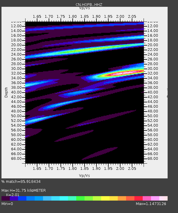
| Estimated Moho Depth: |
31.75 km |
| Estimated Crust Vp/Vs: |
2.01 |
| Assumed Crust Vp: |
6.566 km/s |
| Estimated Crust Vs: |
3.267 km/s |
| Estimated Crust Poisson's Ratio: |
0.34 |
|
| Radial Match: |
85.918434 % |
| Radial Bump: |
400 |
| Transverse Match: |
61.708897 % |
| Transverse Bump: |
400 |
| SOD ConfigId: |
23341671 |
| Insert Time: |
2021-02-24 14:27:36.196 +0000 |
| GWidth: |
2.5 |
| Max Bumps: |
400 |
| Tol: |
0.001 |
|

Signal To Noise
| Channel | StoN | STA | LTA |
| CN:HOPB: :HHZ:20210210T13:32:39.620027Z | 1.3189651 | 6.5262753E-7 | 4.9480275E-7 |
| CN:HOPB: :HHN:20210210T13:32:39.620027Z | 1.0992717 | 3.4419384E-7 | 3.1311083E-7 |
| CN:HOPB: :HHE:20210210T13:32:39.620027Z | 1.8718058 | 8.984556E-7 | 4.79994E-7 |
| Arrivals |
| Ps | 5.0 SECOND |
| PpPs | 14 SECOND |
| PsPs/PpSs | 19 SECOND |


