You are here: Home > Network List > HV - Hawaiian Volcano Observatory Network Stations List
> Station ERZ4 East Rift Zone 4 Temporary > Earthquake Result Viewer
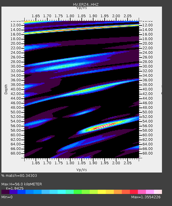
ERZ4 East Rift Zone 4 Temporary - Earthquake Result Viewer
| Earthquake location: |
Southeast Of Loyalty Islands |
| Earthquake latitude/longitude: |
-23.1/171.6 |
| Earthquake time(UTC): |
2021/02/10 (041) 13:19:55 GMT |
| Earthquake Depth: |
10 km |
| Earthquake Magnitude: |
7.7 mww |
| Earthquake Catalog/Contributor: |
NEIC PDE/us |
|
| Network: |
HV Hawaiian Volcano Observatory Network |
| Station: |
ERZ4 East Rift Zone 4 Temporary |
| Lat/Lon: |
19.52 N/154.86 W |
| Elevation: |
80 m |
|
| Distance: |
53.5 deg |
| Az: |
40.414 deg |
| Baz: |
219.277 deg |
| Ray Param: |
0.06607245 |
| Estimated Moho Depth: |
56.0 km |
| Estimated Crust Vp/Vs: |
1.94 |
| Assumed Crust Vp: |
5.195 km/s |
| Estimated Crust Vs: |
2.674 km/s |
| Estimated Crust Poisson's Ratio: |
0.32 |
|
| Radial Match: |
80.34303 % |
| Radial Bump: |
400 |
| Transverse Match: |
48.507423 % |
| Transverse Bump: |
400 |
| SOD ConfigId: |
23341671 |
| Insert Time: |
2021-02-24 14:28:26.375 +0000 |
| GWidth: |
2.5 |
| Max Bumps: |
400 |
| Tol: |
0.001 |
|

Signal To Noise
| Channel | StoN | STA | LTA |
| HV:ERZ4: :HHZ:20210210T13:28:45.355012Z | 2.205296 | 4.76747E-6 | 2.1618275E-6 |
| HV:ERZ4: :HHN:20210210T13:28:45.355012Z | 2.8289902 | 1.2843258E-5 | 4.5398738E-6 |
| HV:ERZ4: :HHE:20210210T13:28:45.355012Z | 0.56315 | 3.3264178E-6 | 5.906806E-6 |
| Arrivals |
| Ps | 10 SECOND |
| PpPs | 31 SECOND |
| PsPs/PpSs | 41 SECOND |


