You are here: Home > Network List > NN - Western Great Basin/Eastern Sierra Nevada Stations List
> Station QSM Queen of Sheba Mine, CA. (GPS 01/17/2001) w84gm > Earthquake Result Viewer
QSM Queen of Sheba Mine, CA. (GPS 01/17/2001) w84gm - Earthquake Result Viewer
| Earthquake location: |
Southeast Of Loyalty Islands |
| Earthquake latitude/longitude: |
-23.1/171.6 |
| Earthquake time(UTC): |
2021/02/10 (041) 13:19:55 GMT |
| Earthquake Depth: |
10 km |
| Earthquake Magnitude: |
7.7 mww |
| Earthquake Catalog/Contributor: |
NEIC PDE/us |
|
| Network: |
NN Western Great Basin/Eastern Sierra Nevada |
| Station: |
QSM Queen of Sheba Mine, CA. (GPS 01/17/2001) w84gm |
| Lat/Lon: |
35.97 N/116.87 W |
| Elevation: |
385 m |
|
| Distance: |
89.5 deg |
| Az: |
50.308 deg |
| Baz: |
240.888 deg |
| Ray Param: |
0.04182065 |
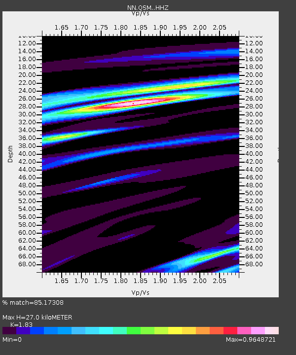
| Estimated Moho Depth: |
27.0 km |
| Estimated Crust Vp/Vs: |
1.83 |
| Assumed Crust Vp: |
6.276 km/s |
| Estimated Crust Vs: |
3.429 km/s |
| Estimated Crust Poisson's Ratio: |
0.29 |
|
| Radial Match: |
85.17308 % |
| Radial Bump: |
400 |
| Transverse Match: |
68.99183 % |
| Transverse Bump: |
400 |
| SOD ConfigId: |
23341671 |
| Insert Time: |
2021-02-24 14:29:46.699 +0000 |
| GWidth: |
2.5 |
| Max Bumps: |
400 |
| Tol: |
0.001 |
|

Signal To Noise
| Channel | StoN | STA | LTA |
| NN:QSM: :HHZ:20210210T13:32:21.517976Z | 1.5148283 | 9.0140406E-7 | 5.950536E-7 |
| NN:QSM: :HHN:20210210T13:32:21.517976Z | 0.7372882 | 5.4313267E-7 | 7.366626E-7 |
| NN:QSM: :HHE:20210210T13:32:21.517976Z | 0.70588785 | 6.092972E-7 | 8.6316436E-7 |
| Arrivals |
| Ps | 3.6 SECOND |
| PpPs | 12 SECOND |
| PsPs/PpSs | 16 SECOND |


