You are here: Home > Network List > GE - GEOFON Stations List
> Station WLF GEOFON Station Walferdange, Luxembourg > Earthquake Result Viewer
WLF GEOFON Station Walferdange, Luxembourg - Earthquake Result Viewer
| Earthquake location: |
Kuril Islands |
| Earthquake latitude/longitude: |
44.6/149.4 |
| Earthquake time(UTC): |
1995/12/03 (337) 18:01:08 GMT |
| Earthquake Depth: |
33 km |
| Earthquake Magnitude: |
6.6 MB, 8.0 MS |
| Earthquake Catalog/Contributor: |
WHDF/NEIC |
|
| Network: |
GE GEOFON |
| Station: |
WLF GEOFON Station Walferdange, Luxembourg |
| Lat/Lon: |
49.66 N/6.15 E |
| Elevation: |
295 m |
|
| Distance: |
80.8 deg |
| Az: |
336.791 deg |
| Baz: |
25.69 deg |
| Ray Param: |
0.047975697 |
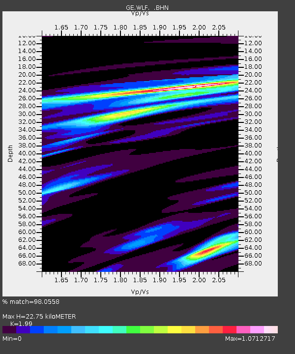
| Estimated Moho Depth: |
22.75 km |
| Estimated Crust Vp/Vs: |
1.99 |
| Assumed Crust Vp: |
6.182 km/s |
| Estimated Crust Vs: |
3.107 km/s |
| Estimated Crust Poisson's Ratio: |
0.33 |
|
| Radial Match: |
98.0558 % |
| Radial Bump: |
364 |
| Transverse Match: |
90.11181 % |
| Transverse Bump: |
400 |
| SOD ConfigId: |
6273 |
| Insert Time: |
2010-03-09 05:16:36.005 +0000 |
| GWidth: |
2.5 |
| Max Bumps: |
400 |
| Tol: |
0.001 |
|

Signal To Noise
| Channel | StoN | STA | LTA |
| GE:WLF: :BHN:19951203T18:12:47.802002Z | 1.196898 | 5.44575E-7 | 4.5498868E-7 |
| GE:WLF: :BHE:19951203T18:12:47.802002Z | 0.8524082 | 3.1955508E-7 | 3.7488505E-7 |
| GE:WLF: :BHZ:19951203T18:12:47.802002Z | 5.008217 | 2.24192E-6 | 4.476483E-7 |
| Arrivals |
| Ps | 3.7 SECOND |
| PpPs | 11 SECOND |
| PsPs/PpSs | 14 SECOND |


