You are here: Home > Network List > SN - Southern Great Basin Network Stations List
> Station HEL Hell's Gate, California w84 > Earthquake Result Viewer
HEL Hell's Gate, California w84 - Earthquake Result Viewer
| Earthquake location: |
Southeast Of Loyalty Islands |
| Earthquake latitude/longitude: |
-23.1/171.6 |
| Earthquake time(UTC): |
2021/02/10 (041) 13:19:55 GMT |
| Earthquake Depth: |
10 km |
| Earthquake Magnitude: |
7.7 mww |
| Earthquake Catalog/Contributor: |
NEIC PDE/us |
|
| Network: |
SN Southern Great Basin Network |
| Station: |
HEL Hell's Gate, California w84 |
| Lat/Lon: |
36.72 N/116.98 W |
| Elevation: |
747 m |
|
| Distance: |
89.8 deg |
| Az: |
49.604 deg |
| Baz: |
240.82 deg |
| Ray Param: |
0.041731797 |
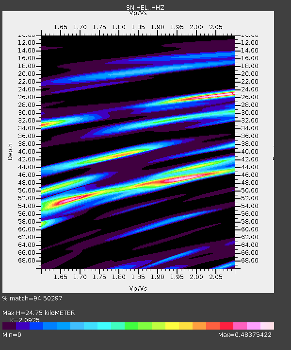
| Estimated Moho Depth: |
24.75 km |
| Estimated Crust Vp/Vs: |
2.09 |
| Assumed Crust Vp: |
6.279 km/s |
| Estimated Crust Vs: |
3.001 km/s |
| Estimated Crust Poisson's Ratio: |
0.35 |
|
| Radial Match: |
94.50297 % |
| Radial Bump: |
369 |
| Transverse Match: |
70.36348 % |
| Transverse Bump: |
400 |
| SOD ConfigId: |
23341671 |
| Insert Time: |
2021-02-24 14:30:52.362 +0000 |
| GWidth: |
2.5 |
| Max Bumps: |
400 |
| Tol: |
0.001 |
|

Signal To Noise
| Channel | StoN | STA | LTA |
| SN:HEL: :HHZ:20210210T13:32:22.887971Z | 2.1013103 | 7.507284E-7 | 3.5726683E-7 |
| SN:HEL: :HHN:20210210T13:32:22.887971Z | 1.2231854 | 3.5966897E-7 | 2.9404288E-7 |
| SN:HEL: :HHE:20210210T13:32:22.887971Z | 0.6112976 | 1.9953418E-7 | 3.2641088E-7 |
| Arrivals |
| Ps | 4.4 SECOND |
| PpPs | 12 SECOND |
| PsPs/PpSs | 16 SECOND |


