You are here: Home > Network List > TA - USArray Transportable Network (new EarthScope stations) Stations List
> Station L15K Ungalak Mountain, AK, USA > Earthquake Result Viewer
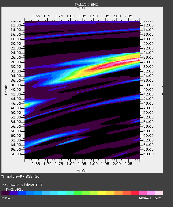
L15K Ungalak Mountain, AK, USA - Earthquake Result Viewer
| Earthquake location: |
Southeast Of Loyalty Islands |
| Earthquake latitude/longitude: |
-23.1/171.6 |
| Earthquake time(UTC): |
2021/02/10 (041) 13:19:55 GMT |
| Earthquake Depth: |
10 km |
| Earthquake Magnitude: |
7.7 mww |
| Earthquake Catalog/Contributor: |
NEIC PDE/us |
|
| Network: |
TA USArray Transportable Network (new EarthScope stations) |
| Station: |
L15K Ungalak Mountain, AK, USA |
| Lat/Lon: |
61.68 N/161.49 W |
| Elevation: |
219 m |
|
| Distance: |
87.2 deg |
| Az: |
12.481 deg |
| Baz: |
204.671 deg |
| Ray Param: |
0.043521345 |
| Estimated Moho Depth: |
26.5 km |
| Estimated Crust Vp/Vs: |
2.09 |
| Assumed Crust Vp: |
6.182 km/s |
| Estimated Crust Vs: |
2.954 km/s |
| Estimated Crust Poisson's Ratio: |
0.35 |
|
| Radial Match: |
97.859436 % |
| Radial Bump: |
203 |
| Transverse Match: |
83.93966 % |
| Transverse Bump: |
400 |
| SOD ConfigId: |
23341671 |
| Insert Time: |
2021-02-24 14:31:13.331 +0000 |
| GWidth: |
2.5 |
| Max Bumps: |
400 |
| Tol: |
0.001 |
|

Signal To Noise
| Channel | StoN | STA | LTA |
| TA:L15K: :BHZ:20210210T13:32:10.55002Z | 2.536011 | 9.57212E-7 | 3.774479E-7 |
| TA:L15K: :BHN:20210210T13:32:10.55002Z | 1.2112015 | 3.486629E-7 | 2.878653E-7 |
| TA:L15K: :BHE:20210210T13:32:10.55002Z | 0.33122241 | 1.686342E-7 | 5.0912683E-7 |
| Arrivals |
| Ps | 4.8 SECOND |
| PpPs | 13 SECOND |
| PsPs/PpSs | 18 SECOND |


