You are here: Home > Network List > TA - USArray Transportable Network (new EarthScope stations) Stations List
> Station O17K Koliganek, Bristol Bay, AK, USA > Earthquake Result Viewer
O17K Koliganek, Bristol Bay, AK, USA - Earthquake Result Viewer
| Earthquake location: |
Southeast Of Loyalty Islands |
| Earthquake latitude/longitude: |
-23.1/171.6 |
| Earthquake time(UTC): |
2021/02/10 (041) 13:19:55 GMT |
| Earthquake Depth: |
10 km |
| Earthquake Magnitude: |
7.7 mww |
| Earthquake Catalog/Contributor: |
NEIC PDE/us |
|
| Network: |
TA USArray Transportable Network (new EarthScope stations) |
| Station: |
O17K Koliganek, Bristol Bay, AK, USA |
| Lat/Lon: |
59.77 N/157.09 W |
| Elevation: |
156 m |
|
| Distance: |
86.4 deg |
| Az: |
15.272 deg |
| Baz: |
208.654 deg |
| Ray Param: |
0.04406061 |
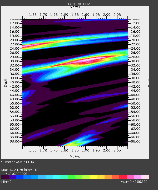
| Estimated Moho Depth: |
28.75 km |
| Estimated Crust Vp/Vs: |
1.93 |
| Assumed Crust Vp: |
6.276 km/s |
| Estimated Crust Vs: |
3.252 km/s |
| Estimated Crust Poisson's Ratio: |
0.32 |
|
| Radial Match: |
96.61186 % |
| Radial Bump: |
235 |
| Transverse Match: |
84.990234 % |
| Transverse Bump: |
400 |
| SOD ConfigId: |
23341671 |
| Insert Time: |
2021-02-24 14:31:27.812 +0000 |
| GWidth: |
2.5 |
| Max Bumps: |
400 |
| Tol: |
0.001 |
|
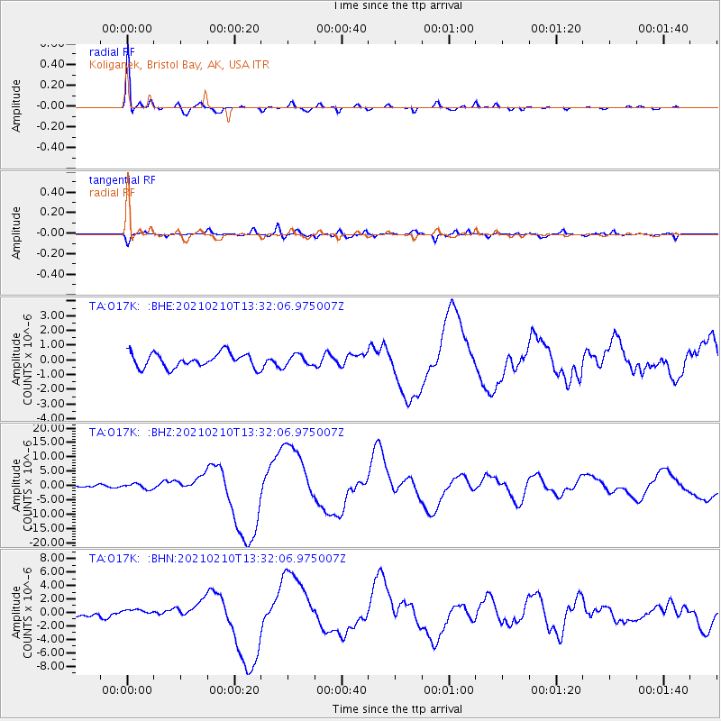
Signal To Noise
| Channel | StoN | STA | LTA |
| TA:O17K: :BHZ:20210210T13:32:06.975007Z | 2.668614 | 9.317985E-7 | 3.4916945E-7 |
| TA:O17K: :BHN:20210210T13:32:06.975007Z | 1.0745275 | 4.6372574E-7 | 4.3156246E-7 |
| TA:O17K: :BHE:20210210T13:32:06.975007Z | 0.7460279 | 3.6404313E-7 | 4.879752E-7 |
| Arrivals |
| Ps | 4.3 SECOND |
| PpPs | 13 SECOND |
| PsPs/PpSs | 18 SECOND |


