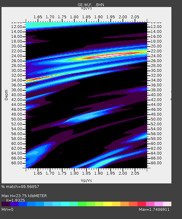
WLF GEOFON Station Walferdange, Luxembourg - Earthquake Result Viewer

Earthquake location: Northern Mid-Atlantic Ridge
Earthquake latitude/longitude: 33.8/-38.6
Earthquake time(UTC): 1995/04/17 (107) 07:14:35 GMT
Earthquake Depth: 10 km
Earthquake Magnitude: 5.8 MB, 5.8 MS, 5.9 UNKNOWN, 6.1 MW
Earthquake Catalog/Contributor: WHDF/NEIC
Network: GE GEOFON
Station: WLF GEOFON Station Walferdange, Luxembourg
Lat/Lon: 49.66 N/6.15 E
Elevation: 295 m
Distance: 36.4 deg
Az: 50.453 deg
Baz: 261.273 deg
Ray Param: 0.076706626
Estimated Moho Depth: 23.75 km
Estimated Crust Vp/Vs: 1.93
Assumed Crust Vp: 6.182 km/s
Estimated Crust Vs: 3.199 km/s
Estimated Crust Poisson's Ratio: 0.32
Radial Match: 89.96857 %
Radial Bump: 349
Transverse Match: 71.74308 %
Transverse Bump: 400
SOD ConfigId: 6273
Insert Time: 2010-03-09 05:16:49.322 +0000
GWidth: 2.5
Max Bumps: 400
Tol: 0.001

Signal To Noise

ChannelStoNSTALTA
GE:WLF: :BHN:19950417T07:21:08.80199Z1.19305961.16681704E-79.78004E-8
GE:WLF: :BHE:19950417T07:21:08.80199Z5.41915467.9774804E-71.4720894E-7
GE:WLF: :BHZ:19950417T07:21:08.80199Z12.6532051.2948071E-61.02330375E-7
Arrivals
Ps3.8 SECOND
PpPs11 SECOND
PsPs/PpSs14 SECOND