You are here: Home > Network List > PQ - Public Safety Geoscience Program Canadian Research Network (PSGP) Stations List
> Station HAKB Hakai Institute, Calvert Island, BC > Earthquake Result Viewer
HAKB Hakai Institute, Calvert Island, BC - Earthquake Result Viewer
| Earthquake location: |
Southeast Of Loyalty Islands |
| Earthquake latitude/longitude: |
-23.1/171.6 |
| Earthquake time(UTC): |
2021/02/10 (041) 13:19:55 GMT |
| Earthquake Depth: |
10 km |
| Earthquake Magnitude: |
7.7 mww |
| Earthquake Catalog/Contributor: |
NEIC PDE/us |
|
| Network: |
PQ Public Safety Geoscience Program Canadian Research Network (PSGP) |
| Station: |
HAKB Hakai Institute, Calvert Island, BC |
| Lat/Lon: |
51.65 N/128.14 W |
| Elevation: |
45 m |
|
| Distance: |
91.1 deg |
| Az: |
32.758 deg |
| Baz: |
233.12 deg |
| Ray Param: |
0.041642386 |
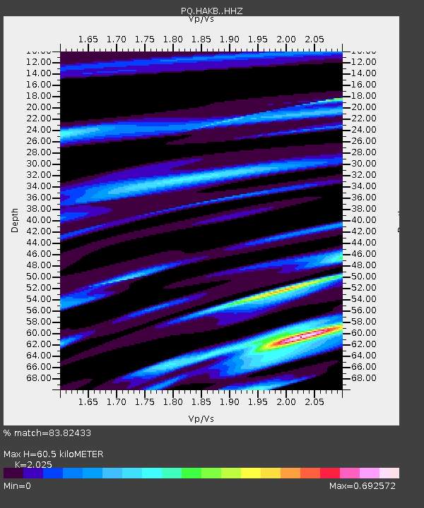
| Estimated Moho Depth: |
60.5 km |
| Estimated Crust Vp/Vs: |
2.03 |
| Assumed Crust Vp: |
6.24 km/s |
| Estimated Crust Vs: |
3.081 km/s |
| Estimated Crust Poisson's Ratio: |
0.34 |
|
| Radial Match: |
83.82433 % |
| Radial Bump: |
362 |
| Transverse Match: |
79.96723 % |
| Transverse Bump: |
400 |
| SOD ConfigId: |
23341671 |
| Insert Time: |
2021-02-24 14:34:01.578 +0000 |
| GWidth: |
2.5 |
| Max Bumps: |
400 |
| Tol: |
0.001 |
|

Signal To Noise
| Channel | StoN | STA | LTA |
| PQ:HAKB: :HHZ:20210210T13:32:29.189973Z | 3.617346 | 1.3673555E-6 | 3.7799967E-7 |
| PQ:HAKB: :HHN:20210210T13:32:29.189973Z | 1.83786 | 8.3588924E-7 | 4.548166E-7 |
| PQ:HAKB: :HHE:20210210T13:32:29.189973Z | 2.0929172 | 1.0811813E-6 | 5.1659055E-7 |
| Arrivals |
| Ps | 10 SECOND |
| PpPs | 29 SECOND |
| PsPs/PpSs | 39 SECOND |


