You are here: Home > Network List > GE - GEOFON Stations List
> Station WLF GEOFON Station Walferdange, Luxembourg > Earthquake Result Viewer
WLF GEOFON Station Walferdange, Luxembourg - Earthquake Result Viewer
| Earthquake location: |
Myanmar-India Border Region |
| Earthquake latitude/longitude: |
25.0/95.3 |
| Earthquake time(UTC): |
1995/05/06 (126) 01:59:07 GMT |
| Earthquake Depth: |
122 km |
| Earthquake Magnitude: |
6.4 MB, 6.5 UNKNOWN, 6.4 MW |
| Earthquake Catalog/Contributor: |
WHDF/NEIC |
|
| Network: |
GE GEOFON |
| Station: |
WLF GEOFON Station Walferdange, Luxembourg |
| Lat/Lon: |
49.66 N/6.15 E |
| Elevation: |
295 m |
|
| Distance: |
70.9 deg |
| Az: |
316.547 deg |
| Baz: |
73.815 deg |
| Ray Param: |
0.054402027 |
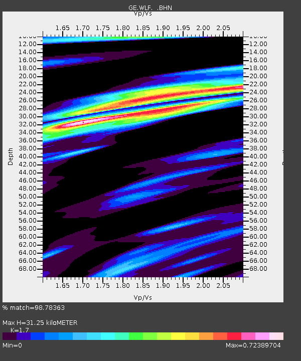
| Estimated Moho Depth: |
31.25 km |
| Estimated Crust Vp/Vs: |
1.70 |
| Assumed Crust Vp: |
6.182 km/s |
| Estimated Crust Vs: |
3.637 km/s |
| Estimated Crust Poisson's Ratio: |
0.24 |
|
| Radial Match: |
98.78363 % |
| Radial Bump: |
328 |
| Transverse Match: |
97.361946 % |
| Transverse Bump: |
400 |
| SOD ConfigId: |
6273 |
| Insert Time: |
2010-03-09 05:16:51.758 +0000 |
| GWidth: |
2.5 |
| Max Bumps: |
400 |
| Tol: |
0.001 |
|

Signal To Noise
| Channel | StoN | STA | LTA |
| GE:WLF: :BHN:19950506T02:09:40.252014Z | 6.12615 | 5.19595E-7 | 8.4815916E-8 |
| GE:WLF: :BHE:19950506T02:09:40.252014Z | 21.082823 | 1.584662E-6 | 7.5163655E-8 |
| GE:WLF: :BHZ:19950506T02:09:40.252014Z | 57.821003 | 4.0702025E-6 | 7.0393156E-8 |
| Arrivals |
| Ps | 3.7 SECOND |
| PpPs | 13 SECOND |
| PsPs/PpSs | 17 SECOND |


