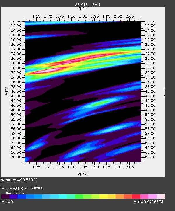
WLF GEOFON Station Walferdange, Luxembourg - Earthquake Result Viewer

Earthquake location: Myanmar-China Border Region
Earthquake latitude/longitude: 21.9/99.2
Earthquake time(UTC): 1995/07/11 (192) 21:46:39 GMT
Earthquake Depth: 13 km
Earthquake Magnitude: 6.1 MB, 7.2 MS, 6.9 UNKNOWN, 6.8 MW
Earthquake Catalog/Contributor: WHDF/NEIC
Network: GE GEOFON
Station: WLF GEOFON Station Walferdange, Luxembourg
Lat/Lon: 49.66 N/6.15 E
Elevation: 295 m
Distance: 75.5 deg
Az: 317.911 deg
Baz: 73.289 deg
Ray Param: 0.051630676
Estimated Moho Depth: 31.0 km
Estimated Crust Vp/Vs: 1.69
Assumed Crust Vp: 6.182 km/s
Estimated Crust Vs: 3.653 km/s
Estimated Crust Poisson's Ratio: 0.23
Radial Match: 98.56029 %
Radial Bump: 252
Transverse Match: 94.034065 %
Transverse Bump: 400
SOD ConfigId: 6273
Insert Time: 2010-03-09 05:16:56.995 +0000
GWidth: 2.5
Max Bumps: 400
Tol: 0.001

Signal To Noise

ChannelStoNSTALTA
GE:WLF: :BHN:19950711T21:57:52.153003Z1.37461449.001668E-86.548503E-8
GE:WLF: :BHE:19950711T21:57:52.153003Z1.24948627.294099E-85.837679E-8
GE:WLF: :BHZ:19950711T21:57:52.153003Z2.0210021.7243057E-78.531935E-8
Arrivals
Ps3.6 SECOND
PpPs13 SECOND
PsPs/PpSs17 SECOND