You are here: Home > Network List > ND - New CaleDonia Broadband Seismic Network Stations List
> Station KOUNC Koumac, New Caledonia > Earthquake Result Viewer
KOUNC Koumac, New Caledonia - Earthquake Result Viewer

| Earthquake location: |
Rat Islands, Aleutian Islands |
| Earthquake latitude/longitude: |
52.4/176.8 |
| Earthquake time(UTC): |
2017/10/08 (281) 22:34:33 GMT |
| Earthquake Depth: |
112 km |
| Earthquake Magnitude: |
6.6 mww |
| Earthquake Catalog/Contributor: |
NEIC PDE/us |
|
| Network: |
ND New CaleDonia Broadband Seismic Network |
| Station: |
KOUNC Koumac, New Caledonia |
| Lat/Lon: |
20.55 S/164.29 E |
| Elevation: |
88 m |
|
| Distance: |
73.5 deg |
| Az: |
192.234 deg |
| Baz: |
7.955 deg |
| Ray Param: |
0.05268484 |
| Estimated Moho Depth: |
21.25 km |
| Estimated Crust Vp/Vs: |
1.99 |
| Assumed Crust Vp: |
5.14 km/s |
| Estimated Crust Vs: |
2.583 km/s |
| Estimated Crust Poisson's Ratio: |
0.33 |
|
| Radial Match: |
83.347855 % |
| Radial Bump: |
400 |
| Transverse Match: |
82.82994 % |
| Transverse Bump: |
400 |
| SOD ConfigId: |
2364251 |
| Insert Time: |
2017-10-22 22:46:44.740 +0000 |
| GWidth: |
2.5 |
| Max Bumps: |
400 |
| Tol: |
0.001 |
|
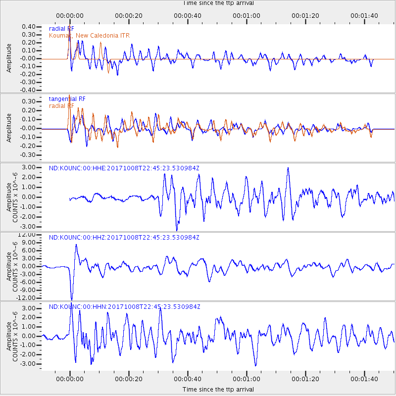
Signal To Noise
| Channel | StoN | STA | LTA |
| ND:KOUNC:00:HHZ:20171008T22:45:23.530984Z | 17.557137 | 5.5952414E-6 | 3.186876E-7 |
| ND:KOUNC:00:HHN:20171008T22:45:23.530984Z | 10.828059 | 1.7134915E-6 | 1.582455E-7 |
| ND:KOUNC:00:HHE:20171008T22:45:23.530984Z | 6.0694222 | 1.2308157E-6 | 2.0278961E-7 |
| Arrivals |
| Ps | 4.2 SECOND |
| PpPs | 12 SECOND |
| PsPs/PpSs | 16 SECOND |


