You are here: Home > Network List > TA - USArray Transportable Network (new EarthScope stations) Stations List
> Station G31M Satah River, YT, CAN > Earthquake Result Viewer
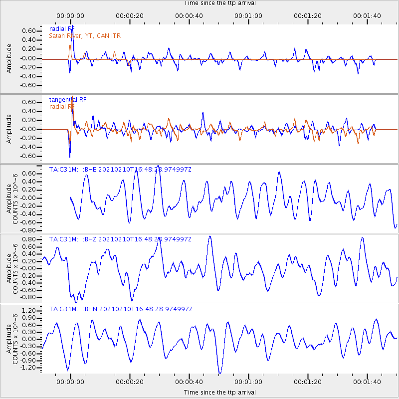
G31M Satah River, YT, CAN - Earthquake Result Viewer
*The percent match for this event was below the threshold and hence no stack was calculated.
| Earthquake location: |
Southeast Of Loyalty Islands |
| Earthquake latitude/longitude: |
-22.8/171.1 |
| Earthquake time(UTC): |
2021/02/10 (041) 16:35:23 GMT |
| Earthquake Depth: |
10 km |
| Earthquake Magnitude: |
6.1 mww |
| Earthquake Catalog/Contributor: |
NEIC PDE/us |
|
| Network: |
TA USArray Transportable Network (new EarthScope stations) |
| Station: |
G31M Satah River, YT, CAN |
| Lat/Lon: |
66.92 N/134.27 W |
| Elevation: |
61 m |
|
| Distance: |
98.3 deg |
| Az: |
18.962 deg |
| Baz: |
229.502 deg |
| Ray Param: |
$rayparam |
*The percent match for this event was below the threshold and hence was not used in the summary stack. |
|
| Radial Match: |
51.38253 % |
| Radial Bump: |
400 |
| Transverse Match: |
55.78003 % |
| Transverse Bump: |
400 |
| SOD ConfigId: |
23341671 |
| Insert Time: |
2021-02-24 17:46:51.424 +0000 |
| GWidth: |
2.5 |
| Max Bumps: |
400 |
| Tol: |
0.001 |
|
Signal To Noise
| Channel | StoN | STA | LTA |
| TA:G31M: :BHZ:20210210T16:48:28.974997Z | 2.1355898 | 7.854793E-7 | 3.6780438E-7 |
| TA:G31M: :BHN:20210210T16:48:28.974997Z | 1.516501 | 6.854669E-7 | 4.520056E-7 |
| TA:G31M: :BHE:20210210T16:48:28.974997Z | 1.3528152 | 4.4212055E-7 | 3.2681518E-7 |
| Arrivals |
| Ps | |
| PpPs | |
| PsPs/PpSs | |


