You are here: Home > Network List > NM - Cooperative New Madrid Seismic Network Stations List
> Station HICK Hickman,KY > Earthquake Result Viewer
HICK Hickman,KY - Earthquake Result Viewer
| Earthquake location: |
Rat Islands, Aleutian Islands |
| Earthquake latitude/longitude: |
52.4/176.8 |
| Earthquake time(UTC): |
2017/10/08 (281) 22:34:33 GMT |
| Earthquake Depth: |
112 km |
| Earthquake Magnitude: |
6.6 mww |
| Earthquake Catalog/Contributor: |
NEIC PDE/us |
|
| Network: |
NM Cooperative New Madrid Seismic Network |
| Station: |
HICK Hickman,KY |
| Lat/Lon: |
36.54 N/89.23 W |
| Elevation: |
141 m |
|
| Distance: |
64.2 deg |
| Az: |
63.143 deg |
| Baz: |
317.313 deg |
| Ray Param: |
0.058754142 |
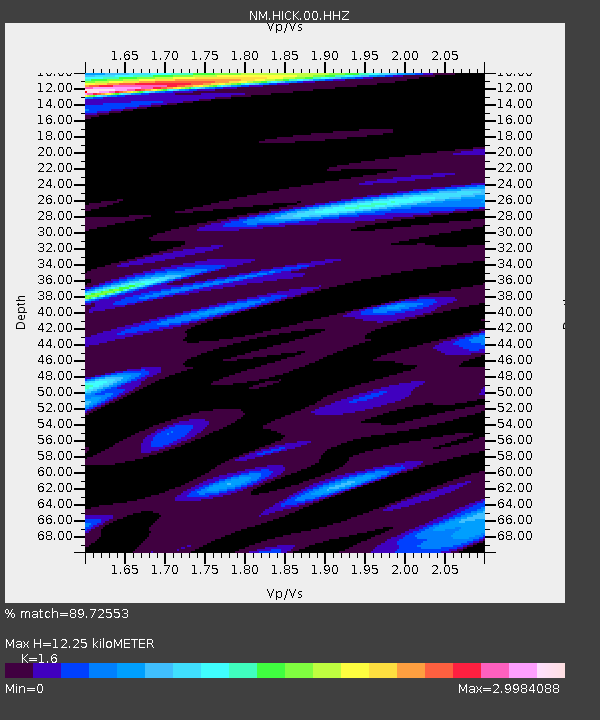
| Estimated Moho Depth: |
12.25 km |
| Estimated Crust Vp/Vs: |
1.60 |
| Assumed Crust Vp: |
6.444 km/s |
| Estimated Crust Vs: |
4.027 km/s |
| Estimated Crust Poisson's Ratio: |
0.18 |
|
| Radial Match: |
89.72553 % |
| Radial Bump: |
400 |
| Transverse Match: |
76.07541 % |
| Transverse Bump: |
400 |
| SOD ConfigId: |
2364251 |
| Insert Time: |
2017-10-22 22:48:10.043 +0000 |
| GWidth: |
2.5 |
| Max Bumps: |
400 |
| Tol: |
0.001 |
|

Signal To Noise
| Channel | StoN | STA | LTA |
| NM:HICK:00:HHZ:20171008T22:44:26.264993Z | 39.83664 | 6.5458353E-6 | 1.6431696E-7 |
| NM:HICK:00:HHN:20171008T22:44:26.264993Z | 8.78016 | 3.7419873E-6 | 4.261867E-7 |
| NM:HICK:00:HHE:20171008T22:44:26.264993Z | 6.2970824 | 2.9683047E-6 | 4.713778E-7 |
| Arrivals |
| Ps | 1.2 SECOND |
| PpPs | 4.7 SECOND |
| PsPs/PpSs | 5.9 SECOND |


