You are here: Home > Network List > NM - Cooperative New Madrid Seismic Network Stations List
> Station UTMT Martin, TN > Earthquake Result Viewer
UTMT Martin, TN - Earthquake Result Viewer
| Earthquake location: |
Rat Islands, Aleutian Islands |
| Earthquake latitude/longitude: |
52.4/176.8 |
| Earthquake time(UTC): |
2017/10/08 (281) 22:34:33 GMT |
| Earthquake Depth: |
112 km |
| Earthquake Magnitude: |
6.6 mww |
| Earthquake Catalog/Contributor: |
NEIC PDE/us |
|
| Network: |
NM Cooperative New Madrid Seismic Network |
| Station: |
UTMT Martin, TN |
| Lat/Lon: |
36.35 N/88.86 W |
| Elevation: |
110 m |
|
| Distance: |
64.6 deg |
| Az: |
63.046 deg |
| Baz: |
317.487 deg |
| Ray Param: |
0.05853466 |
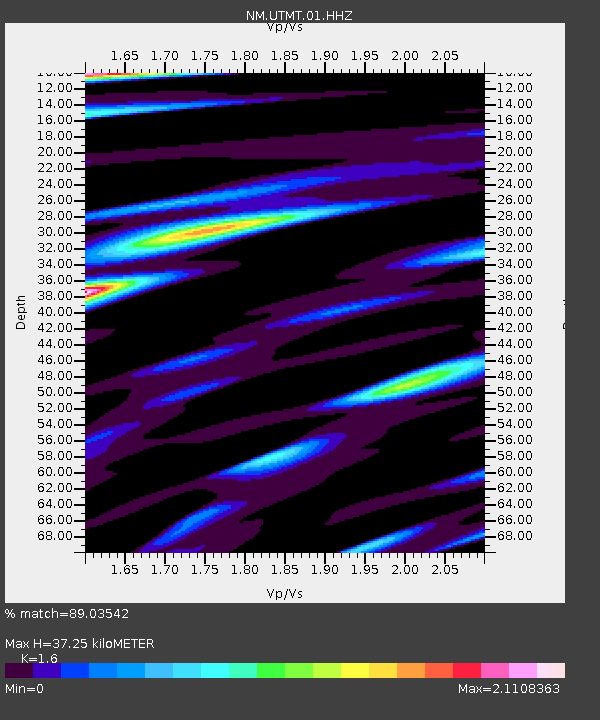
| Estimated Moho Depth: |
37.25 km |
| Estimated Crust Vp/Vs: |
1.60 |
| Assumed Crust Vp: |
6.444 km/s |
| Estimated Crust Vs: |
4.027 km/s |
| Estimated Crust Poisson's Ratio: |
0.18 |
|
| Radial Match: |
89.03542 % |
| Radial Bump: |
400 |
| Transverse Match: |
79.75351 % |
| Transverse Bump: |
400 |
| SOD ConfigId: |
2364251 |
| Insert Time: |
2017-10-22 22:48:38.855 +0000 |
| GWidth: |
2.5 |
| Max Bumps: |
400 |
| Tol: |
0.001 |
|
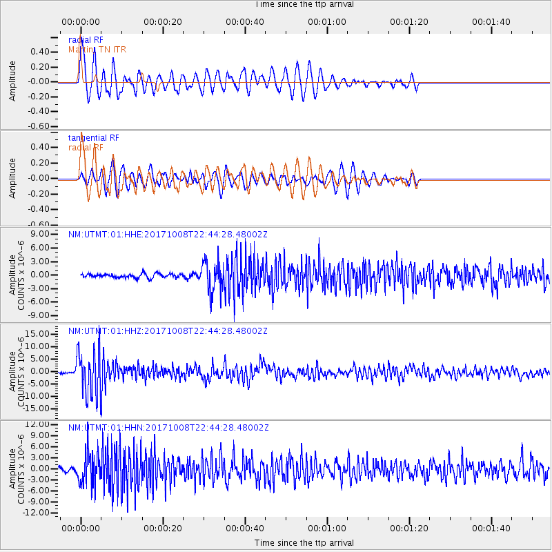
Signal To Noise
| Channel | StoN | STA | LTA |
| NM:UTMT:01:HHZ:20171008T22:44:28.48002Z | 35.004528 | 9.195285E-6 | 2.6268845E-7 |
| NM:UTMT:01:HHN:20171008T22:44:28.48002Z | 10.04789 | 4.346232E-6 | 4.3255173E-7 |
| NM:UTMT:01:HHE:20171008T22:44:28.48002Z | 7.6440234 | 3.3387882E-6 | 4.3678415E-7 |
| Arrivals |
| Ps | 3.6 SECOND |
| PpPs | 14 SECOND |
| PsPs/PpSs | 18 SECOND |


