You are here: Home > Network List > TA - USArray Transportable Network (new EarthScope stations) Stations List
> Station TUL3 Leonard, OK, USA > Earthquake Result Viewer
TUL3 Leonard, OK, USA - Earthquake Result Viewer
| Earthquake location: |
Rat Islands, Aleutian Islands |
| Earthquake latitude/longitude: |
52.4/176.8 |
| Earthquake time(UTC): |
2017/10/08 (281) 22:34:33 GMT |
| Earthquake Depth: |
112 km |
| Earthquake Magnitude: |
6.6 mww |
| Earthquake Catalog/Contributor: |
NEIC PDE/us |
|
| Network: |
TA USArray Transportable Network (new EarthScope stations) |
| Station: |
TUL3 Leonard, OK, USA |
| Lat/Lon: |
35.91 N/95.79 W |
| Elevation: |
265 m |
|
| Distance: |
61.0 deg |
| Az: |
67.962 deg |
| Baz: |
315.666 deg |
| Ray Param: |
0.060819704 |
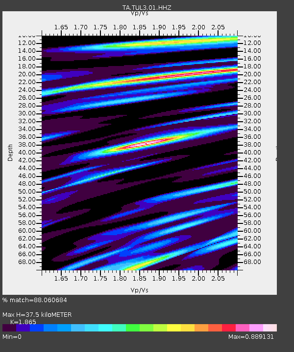
| Estimated Moho Depth: |
37.5 km |
| Estimated Crust Vp/Vs: |
1.87 |
| Assumed Crust Vp: |
6.498 km/s |
| Estimated Crust Vs: |
3.484 km/s |
| Estimated Crust Poisson's Ratio: |
0.30 |
|
| Radial Match: |
88.060684 % |
| Radial Bump: |
400 |
| Transverse Match: |
54.624077 % |
| Transverse Bump: |
400 |
| SOD ConfigId: |
2364251 |
| Insert Time: |
2017-10-22 22:49:12.280 +0000 |
| GWidth: |
2.5 |
| Max Bumps: |
400 |
| Tol: |
0.001 |
|
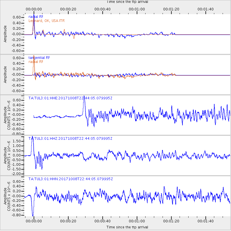
Signal To Noise
| Channel | StoN | STA | LTA |
| TA:TUL3:01:HHZ:20171008T22:44:05.079995Z | 33.785908 | 1.0173229E-6 | 3.0110865E-8 |
| TA:TUL3:01:HHN:20171008T22:44:05.079995Z | 10.228995 | 3.5502492E-7 | 3.4707703E-8 |
| TA:TUL3:01:HHE:20171008T22:44:05.079995Z | 15.962316 | 3.6014617E-7 | 2.2562277E-8 |
| Arrivals |
| Ps | 5.2 SECOND |
| PpPs | 16 SECOND |
| PsPs/PpSs | 21 SECOND |


