You are here: Home > Network List > GE - GEOFON Stations List
> Station WLF GEOFON Station Walferdange, Luxembourg > Earthquake Result Viewer
WLF GEOFON Station Walferdange, Luxembourg - Earthquake Result Viewer
| Earthquake location: |
Hindu Kush Region, Afghanistan |
| Earthquake latitude/longitude: |
36.0/70.7 |
| Earthquake time(UTC): |
2000/05/12 (133) 23:10:29 GMT |
| Earthquake Depth: |
108 km |
| Earthquake Magnitude: |
6.2 MB, 6.3 MW, 6.3 MW |
| Earthquake Catalog/Contributor: |
WHDF/NEIC |
|
| Network: |
GE GEOFON |
| Station: |
WLF GEOFON Station Walferdange, Luxembourg |
| Lat/Lon: |
49.66 N/6.15 E |
| Elevation: |
295 m |
|
| Distance: |
47.8 deg |
| Az: |
307.68 deg |
| Baz: |
81.102 deg |
| Ray Param: |
0.069397435 |
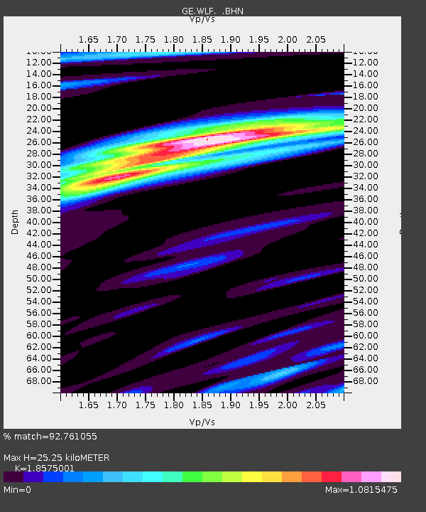
| Estimated Moho Depth: |
25.25 km |
| Estimated Crust Vp/Vs: |
1.86 |
| Assumed Crust Vp: |
6.182 km/s |
| Estimated Crust Vs: |
3.328 km/s |
| Estimated Crust Poisson's Ratio: |
0.30 |
|
| Radial Match: |
92.761055 % |
| Radial Bump: |
400 |
| Transverse Match: |
76.542625 % |
| Transverse Bump: |
400 |
| SOD ConfigId: |
3744 |
| Insert Time: |
2010-03-09 05:18:51.981 +0000 |
| GWidth: |
2.5 |
| Max Bumps: |
400 |
| Tol: |
0.001 |
|

Signal To Noise
| Channel | StoN | STA | LTA |
| GE:WLF: :BHN:20000512T23:18:26.193013Z | 2.6093113 | 2.673063E-7 | 1.0244324E-7 |
| GE:WLF: :BHE:20000512T23:18:26.193013Z | 18.957176 | 1.3133638E-6 | 6.928056E-8 |
| GE:WLF: :BHZ:20000512T23:18:26.193013Z | 23.524536 | 2.5487602E-6 | 1.0834476E-7 |
| Arrivals |
| Ps | 3.7 SECOND |
| PpPs | 11 SECOND |
| PsPs/PpSs | 15 SECOND |


