You are here: Home > Network List > TX - Texas Seismological Network Stations List
> Station FW03 Perrin-Whitt Elementary School > Earthquake Result Viewer
FW03 Perrin-Whitt Elementary School - Earthquake Result Viewer
| Earthquake location: |
Rat Islands, Aleutian Islands |
| Earthquake latitude/longitude: |
52.4/176.8 |
| Earthquake time(UTC): |
2017/10/08 (281) 22:34:33 GMT |
| Earthquake Depth: |
112 km |
| Earthquake Magnitude: |
6.6 mww |
| Earthquake Catalog/Contributor: |
NEIC PDE/us |
|
| Network: |
TX Texas Seismological Network |
| Station: |
FW03 Perrin-Whitt Elementary School |
| Lat/Lon: |
33.04 N/98.07 W |
| Elevation: |
322 m |
|
| Distance: |
61.8 deg |
| Az: |
71.768 deg |
| Baz: |
316.206 deg |
| Ray Param: |
0.060338195 |
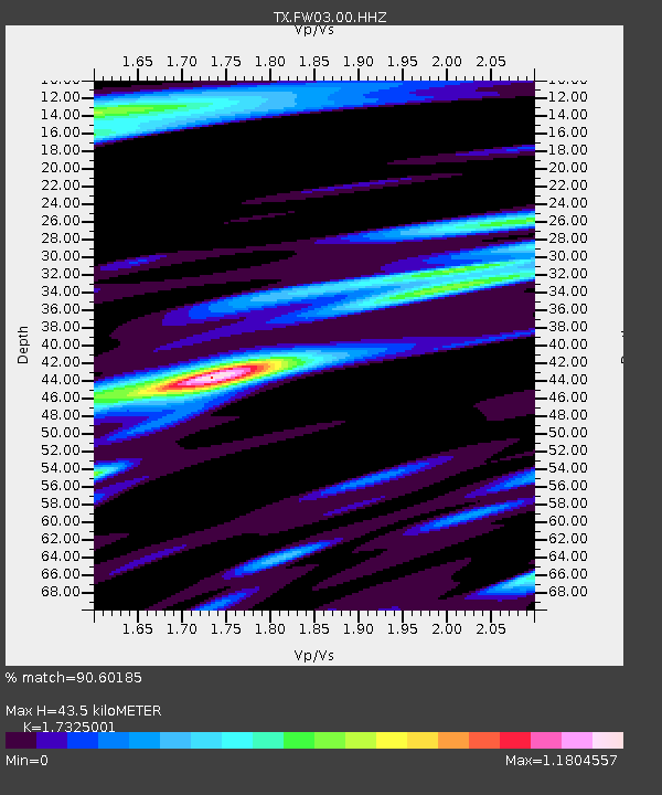
| Estimated Moho Depth: |
43.5 km |
| Estimated Crust Vp/Vs: |
1.73 |
| Assumed Crust Vp: |
6.426 km/s |
| Estimated Crust Vs: |
3.709 km/s |
| Estimated Crust Poisson's Ratio: |
0.25 |
|
| Radial Match: |
90.60185 % |
| Radial Bump: |
400 |
| Transverse Match: |
72.55319 % |
| Transverse Bump: |
400 |
| SOD ConfigId: |
2364251 |
| Insert Time: |
2017-10-22 22:49:29.394 +0000 |
| GWidth: |
2.5 |
| Max Bumps: |
400 |
| Tol: |
0.001 |
|

Signal To Noise
| Channel | StoN | STA | LTA |
| TX:FW03:00:HHZ:20171008T22:44:10.119973Z | 30.592463 | 3.9687247E-6 | 1.2972883E-7 |
| TX:FW03:00:HH1:20171008T22:44:10.119973Z | 14.346785 | 2.128821E-6 | 1.4838314E-7 |
| TX:FW03:00:HH2:20171008T22:44:10.119973Z | 12.750892 | 1.6322936E-6 | 1.2801408E-7 |
| Arrivals |
| Ps | 5.2 SECOND |
| PpPs | 18 SECOND |
| PsPs/PpSs | 23 SECOND |


