You are here: Home > Network List > TA - USArray Transportable Network (new EarthScope stations) Stations List
> Station I17K Unalakleet, AK, USA > Earthquake Result Viewer
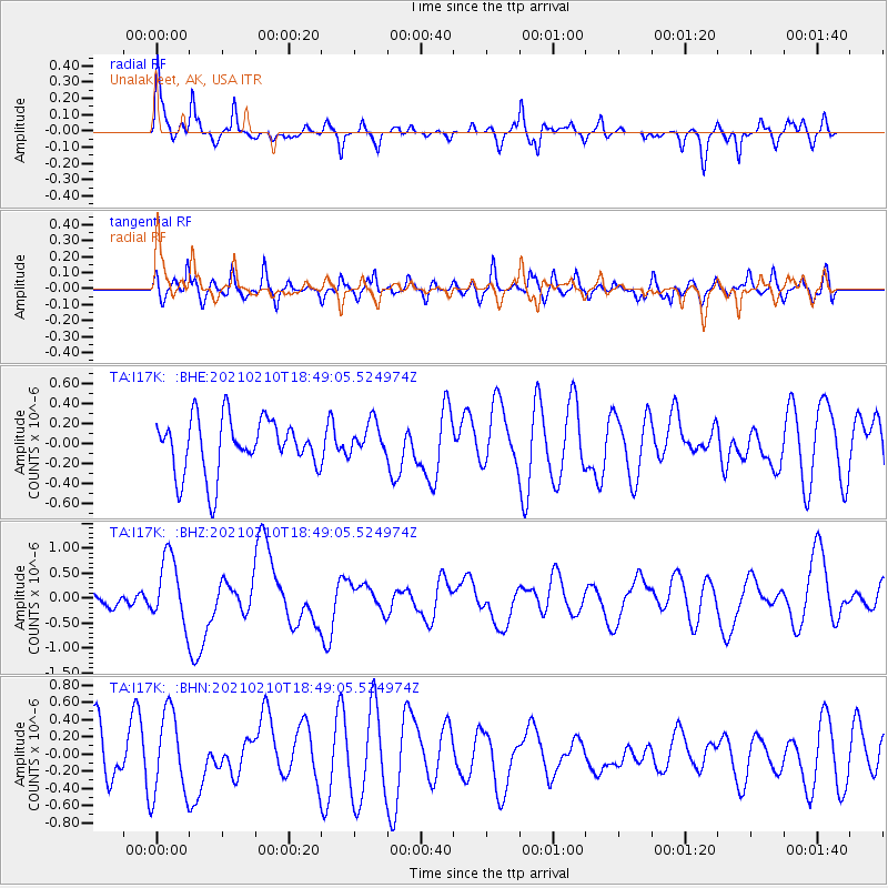
I17K Unalakleet, AK, USA - Earthquake Result Viewer
*The percent match for this event was below the threshold and hence no stack was calculated.
| Earthquake location: |
Southeast Of Loyalty Islands |
| Earthquake latitude/longitude: |
-22.8/171.1 |
| Earthquake time(UTC): |
2021/02/10 (041) 18:36:41 GMT |
| Earthquake Depth: |
10 km |
| Earthquake Magnitude: |
6.1 mww |
| Earthquake Catalog/Contributor: |
NEIC PDE/us |
|
| Network: |
TA USArray Transportable Network (new EarthScope stations) |
| Station: |
I17K Unalakleet, AK, USA |
| Lat/Lon: |
63.89 N/160.70 W |
| Elevation: |
105 m |
|
| Distance: |
89.1 deg |
| Az: |
12.056 deg |
| Baz: |
205.824 deg |
| Ray Param: |
$rayparam |
*The percent match for this event was below the threshold and hence was not used in the summary stack. |
|
| Radial Match: |
58.98239 % |
| Radial Bump: |
290 |
| Transverse Match: |
66.12301 % |
| Transverse Bump: |
400 |
| SOD ConfigId: |
23341671 |
| Insert Time: |
2021-02-24 19:51:31.467 +0000 |
| GWidth: |
2.5 |
| Max Bumps: |
400 |
| Tol: |
0.001 |
|
Signal To Noise
| Channel | StoN | STA | LTA |
| TA:I17K: :BHZ:20210210T18:49:05.524974Z | 2.1218777 | 6.6470506E-7 | 3.1326266E-7 |
| TA:I17K: :BHN:20210210T18:49:05.524974Z | 1.9874686 | 4.8466995E-7 | 2.4386296E-7 |
| TA:I17K: :BHE:20210210T18:49:05.524974Z | 0.6195167 | 1.6903935E-7 | 2.7285682E-7 |
| Arrivals |
| Ps | |
| PpPs | |
| PsPs/PpSs | |


