You are here: Home > Network List > TA - USArray Transportable Network (new EarthScope stations) Stations List
> Station R33M Jennings River, BC, CAN > Earthquake Result Viewer
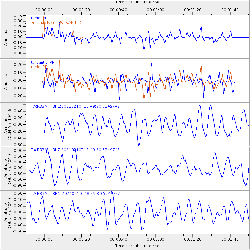
R33M Jennings River, BC, CAN - Earthquake Result Viewer
*The percent match for this event was below the threshold and hence no stack was calculated.
| Earthquake location: |
Southeast Of Loyalty Islands |
| Earthquake latitude/longitude: |
-22.8/171.1 |
| Earthquake time(UTC): |
2021/02/10 (041) 18:36:41 GMT |
| Earthquake Depth: |
10 km |
| Earthquake Magnitude: |
6.1 mww |
| Earthquake Catalog/Contributor: |
NEIC PDE/us |
|
| Network: |
TA USArray Transportable Network (new EarthScope stations) |
| Station: |
R33M Jennings River, BC, CAN |
| Lat/Lon: |
59.39 N/130.97 W |
| Elevation: |
1437 m |
|
| Distance: |
94.6 deg |
| Az: |
25.77 deg |
| Baz: |
231.65 deg |
| Ray Param: |
$rayparam |
*The percent match for this event was below the threshold and hence was not used in the summary stack. |
|
| Radial Match: |
45.589993 % |
| Radial Bump: |
400 |
| Transverse Match: |
46.81266 % |
| Transverse Bump: |
400 |
| SOD ConfigId: |
23341671 |
| Insert Time: |
2021-02-24 19:51:54.663 +0000 |
| GWidth: |
2.5 |
| Max Bumps: |
400 |
| Tol: |
0.001 |
|
Signal To Noise
| Channel | StoN | STA | LTA |
| TA:R33M: :BHZ:20210210T18:49:30.524974Z | 3.3031485 | 5.918745E-7 | 1.7918494E-7 |
| TA:R33M: :BHN:20210210T18:49:30.524974Z | 0.9641005 | 2.2629955E-7 | 2.347261E-7 |
| TA:R33M: :BHE:20210210T18:49:30.524974Z | 0.90730315 | 1.7012187E-7 | 1.8750278E-7 |
| Arrivals |
| Ps | |
| PpPs | |
| PsPs/PpSs | |


