You are here: Home > Network List > TX - Texas Seismological Network Stations List
> Station FW15 Z > Earthquake Result Viewer
FW15 Z - Earthquake Result Viewer
| Earthquake location: |
Rat Islands, Aleutian Islands |
| Earthquake latitude/longitude: |
52.4/176.8 |
| Earthquake time(UTC): |
2017/10/08 (281) 22:34:33 GMT |
| Earthquake Depth: |
112 km |
| Earthquake Magnitude: |
6.6 mww |
| Earthquake Catalog/Contributor: |
NEIC PDE/us |
|
| Network: |
TX Texas Seismological Network |
| Station: |
FW15 Z |
| Lat/Lon: |
32.70 N/97.37 W |
| Elevation: |
192 m |
|
| Distance: |
62.4 deg |
| Az: |
71.55 deg |
| Baz: |
316.48 deg |
| Ray Param: |
0.05991853 |
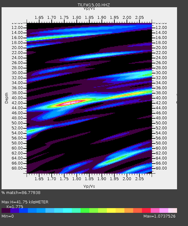
| Estimated Moho Depth: |
41.75 km |
| Estimated Crust Vp/Vs: |
1.77 |
| Assumed Crust Vp: |
6.38 km/s |
| Estimated Crust Vs: |
3.595 km/s |
| Estimated Crust Poisson's Ratio: |
0.27 |
|
| Radial Match: |
86.77938 % |
| Radial Bump: |
400 |
| Transverse Match: |
80.6229 % |
| Transverse Bump: |
400 |
| SOD ConfigId: |
2364251 |
| Insert Time: |
2017-10-22 22:49:55.808 +0000 |
| GWidth: |
2.5 |
| Max Bumps: |
400 |
| Tol: |
0.001 |
|
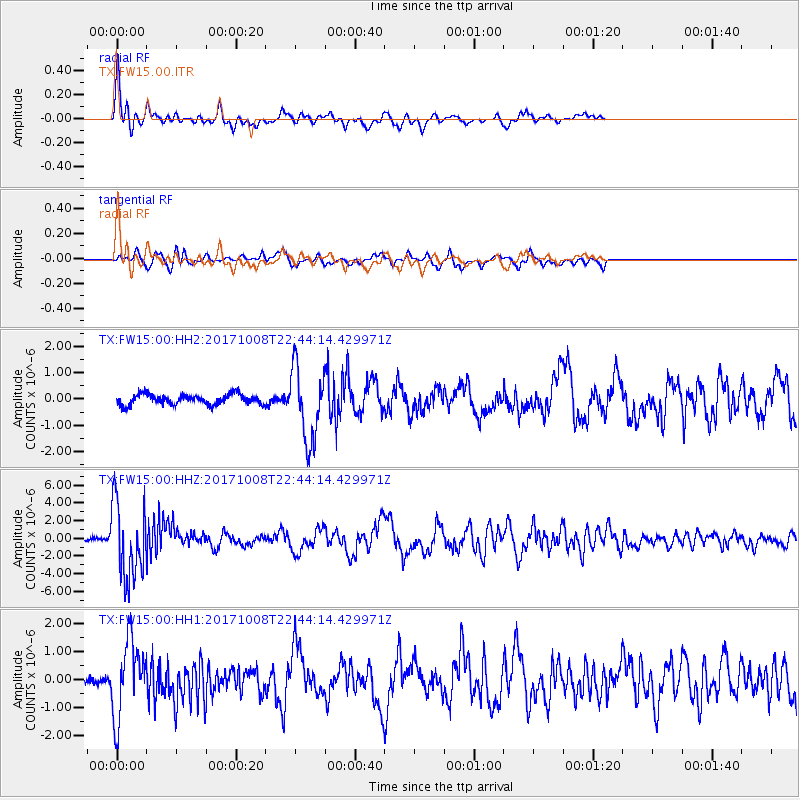
Signal To Noise
| Channel | StoN | STA | LTA |
| TX:FW15:00:HHZ:20171008T22:44:14.429971Z | 19.673126 | 4.2635384E-6 | 2.1671892E-7 |
| TX:FW15:00:HH1:20171008T22:44:14.429971Z | 9.608228 | 1.3545986E-6 | 1.4098319E-7 |
| TX:FW15:00:HH2:20171008T22:44:14.429971Z | 7.1612167 | 1.3829883E-6 | 1.9312198E-7 |
| Arrivals |
| Ps | 5.3 SECOND |
| PpPs | 17 SECOND |
| PsPs/PpSs | 23 SECOND |


