You are here: Home > Network List > AK - Alaska Regional Network Stations List
> Station CUT Chulitna, AK, USA > Earthquake Result Viewer
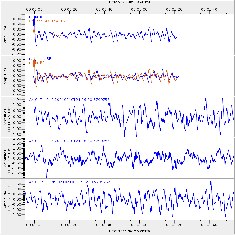
CUT Chulitna, AK, USA - Earthquake Result Viewer
*The percent match for this event was below the threshold and hence no stack was calculated.
| Earthquake location: |
Southeast Of Loyalty Islands |
| Earthquake latitude/longitude: |
-23.3/171.6 |
| Earthquake time(UTC): |
2021/02/10 (041) 21:23:59 GMT |
| Earthquake Depth: |
10 km |
| Earthquake Magnitude: |
6.4 mww |
| Earthquake Catalog/Contributor: |
NEIC PDE/us |
|
| Network: |
AK Alaska Regional Network |
| Station: |
CUT Chulitna, AK, USA |
| Lat/Lon: |
62.41 N/150.26 W |
| Elevation: |
574 m |
|
| Distance: |
90.6 deg |
| Az: |
16.705 deg |
| Baz: |
214.591 deg |
| Ray Param: |
$rayparam |
*The percent match for this event was below the threshold and hence was not used in the summary stack. |
|
| Radial Match: |
69.90536 % |
| Radial Bump: |
400 |
| Transverse Match: |
55.54888 % |
| Transverse Bump: |
400 |
| SOD ConfigId: |
23341671 |
| Insert Time: |
2021-02-24 22:25:37.209 +0000 |
| GWidth: |
2.5 |
| Max Bumps: |
400 |
| Tol: |
0.001 |
|
Signal To Noise
| Channel | StoN | STA | LTA |
| AK:CUT: :BHZ:20210210T21:36:30.579975Z | 1.939093 | 6.0955375E-7 | 3.1434993E-7 |
| AK:CUT: :BHN:20210210T21:36:30.579975Z | 1.3197182 | 5.6155795E-7 | 4.255135E-7 |
| AK:CUT: :BHE:20210210T21:36:30.579975Z | 1.3138933 | 5.810327E-7 | 4.422221E-7 |
| Arrivals |
| Ps | |
| PpPs | |
| PsPs/PpSs | |


