You are here: Home > Network List > GE - GEOFON Stations List
> Station WLF GEOFON Station Walferdange, Luxembourg > Earthquake Result Viewer
WLF GEOFON Station Walferdange, Luxembourg - Earthquake Result Viewer
| Earthquake location: |
Kuril Islands |
| Earthquake latitude/longitude: |
44.2/148.5 |
| Earthquake time(UTC): |
2001/06/24 (175) 13:18:51 GMT |
| Earthquake Depth: |
33 km |
| Earthquake Magnitude: |
5.8 MB, 5.7 MS, 6.0 MW |
| Earthquake Catalog/Contributor: |
WHDF/NEIC |
|
| Network: |
GE GEOFON |
| Station: |
WLF GEOFON Station Walferdange, Luxembourg |
| Lat/Lon: |
49.66 N/6.15 E |
| Elevation: |
295 m |
|
| Distance: |
80.9 deg |
| Az: |
336.304 deg |
| Baz: |
26.419 deg |
| Ray Param: |
0.04790674 |
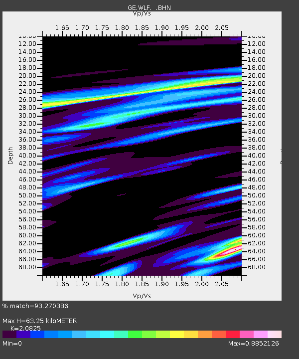
| Estimated Moho Depth: |
63.25 km |
| Estimated Crust Vp/Vs: |
2.08 |
| Assumed Crust Vp: |
6.182 km/s |
| Estimated Crust Vs: |
2.969 km/s |
| Estimated Crust Poisson's Ratio: |
0.35 |
|
| Radial Match: |
93.270386 % |
| Radial Bump: |
400 |
| Transverse Match: |
87.60124 % |
| Transverse Bump: |
400 |
| SOD ConfigId: |
4714 |
| Insert Time: |
2010-03-09 05:19:43.179 +0000 |
| GWidth: |
2.5 |
| Max Bumps: |
400 |
| Tol: |
0.001 |
|

Signal To Noise
| Channel | StoN | STA | LTA |
| GE:WLF: :BHN:20010624T13:30:31.551003Z | 8.218717 | 5.3246345E-7 | 6.47867E-8 |
| GE:WLF: :BHE:20010624T13:30:31.551003Z | 6.2127714 | 2.2691012E-7 | 3.6523176E-8 |
| GE:WLF: :BHZ:20010624T13:30:31.551003Z | 21.03865 | 1.1377138E-6 | 5.4077315E-8 |
| Arrivals |
| Ps | 11 SECOND |
| PpPs | 31 SECOND |
| PsPs/PpSs | 42 SECOND |


