You are here: Home > Network List > GE - GEOFON Stations List
> Station WLF GEOFON Station Walferdange, Luxembourg > Earthquake Result Viewer
WLF GEOFON Station Walferdange, Luxembourg - Earthquake Result Viewer
| Earthquake location: |
Northwest Of Kuril Islands |
| Earthquake latitude/longitude: |
47.8/146.2 |
| Earthquake time(UTC): |
2002/11/17 (321) 04:53:53 GMT |
| Earthquake Depth: |
459 km |
| Earthquake Magnitude: |
7.3 MW, 7.3 MW |
| Earthquake Catalog/Contributor: |
WHDF/NEIC |
|
| Network: |
GE GEOFON |
| Station: |
WLF GEOFON Station Walferdange, Luxembourg |
| Lat/Lon: |
49.66 N/6.15 E |
| Elevation: |
295 m |
|
| Distance: |
76.9 deg |
| Az: |
334.643 deg |
| Baz: |
26.368 deg |
| Ray Param: |
0.049288556 |
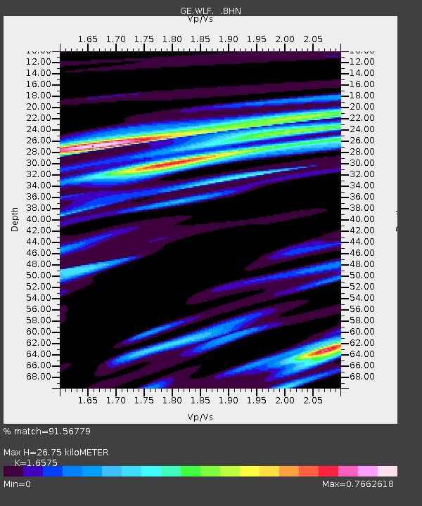
| Estimated Moho Depth: |
26.75 km |
| Estimated Crust Vp/Vs: |
1.66 |
| Assumed Crust Vp: |
6.182 km/s |
| Estimated Crust Vs: |
3.73 km/s |
| Estimated Crust Poisson's Ratio: |
0.21 |
|
| Radial Match: |
91.56779 % |
| Radial Bump: |
369 |
| Transverse Match: |
80.94358 % |
| Transverse Bump: |
400 |
| SOD ConfigId: |
4714 |
| Insert Time: |
2010-03-09 05:20:03.024 +0000 |
| GWidth: |
2.5 |
| Max Bumps: |
400 |
| Tol: |
0.001 |
|

Signal To Noise
| Channel | StoN | STA | LTA |
| GE:WLF: :BHN:20021117T05:04:26.581016Z | 29.17763 | 5.0323915E-6 | 1.7247432E-7 |
| GE:WLF: :BHE:20021117T05:04:26.581016Z | 21.730713 | 2.795706E-6 | 1.2865229E-7 |
| GE:WLF: :BHZ:20021117T05:04:26.581016Z | 103.6321 | 1.3303326E-5 | 1.2837071E-7 |
| Arrivals |
| Ps | 2.9 SECOND |
| PpPs | 11 SECOND |
| PsPs/PpSs | 14 SECOND |


