You are here: Home > Network List > CI - Caltech Regional Seismic Network Stations List
> Station BAR Barrett, Tecate, CA, USA > Earthquake Result Viewer
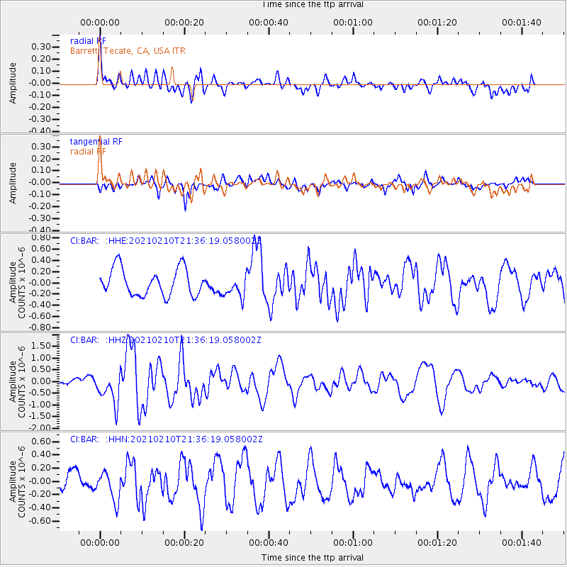
BAR Barrett, Tecate, CA, USA - Earthquake Result Viewer
*The percent match for this event was below the threshold and hence no stack was calculated.
| Earthquake location: |
Southeast Of Loyalty Islands |
| Earthquake latitude/longitude: |
-23.3/171.6 |
| Earthquake time(UTC): |
2021/02/10 (041) 21:23:59 GMT |
| Earthquake Depth: |
10 km |
| Earthquake Magnitude: |
6.4 mww |
| Earthquake Catalog/Contributor: |
NEIC PDE/us |
|
| Network: |
CI Caltech Regional Seismic Network |
| Station: |
BAR Barrett, Tecate, CA, USA |
| Lat/Lon: |
32.68 N/116.67 W |
| Elevation: |
521 m |
|
| Distance: |
88.1 deg |
| Az: |
53.239 deg |
| Baz: |
240.887 deg |
| Ray Param: |
$rayparam |
*The percent match for this event was below the threshold and hence was not used in the summary stack. |
|
| Radial Match: |
58.32745 % |
| Radial Bump: |
400 |
| Transverse Match: |
65.80574 % |
| Transverse Bump: |
400 |
| SOD ConfigId: |
23341671 |
| Insert Time: |
2021-02-24 22:30:30.298 +0000 |
| GWidth: |
2.5 |
| Max Bumps: |
400 |
| Tol: |
0.001 |
|
Signal To Noise
| Channel | StoN | STA | LTA |
| CI:BAR: :HHZ:20210210T21:36:19.058002Z | 3.3685236 | 6.7402937E-7 | 2.0009637E-7 |
| CI:BAR: :HHN:20210210T21:36:19.058002Z | 1.6026903 | 2.1958216E-7 | 1.3700848E-7 |
| CI:BAR: :HHE:20210210T21:36:19.058002Z | 0.8496994 | 2.0310806E-7 | 2.3903522E-7 |
| Arrivals |
| Ps | |
| PpPs | |
| PsPs/PpSs | |


