You are here: Home > Network List > TX - Texas Seismological Network Stations List
> Station SN06 Snyder 6 > Earthquake Result Viewer
SN06 Snyder 6 - Earthquake Result Viewer
| Earthquake location: |
Rat Islands, Aleutian Islands |
| Earthquake latitude/longitude: |
52.4/176.8 |
| Earthquake time(UTC): |
2017/10/08 (281) 22:34:33 GMT |
| Earthquake Depth: |
112 km |
| Earthquake Magnitude: |
6.6 mww |
| Earthquake Catalog/Contributor: |
NEIC PDE/us |
|
| Network: |
TX Texas Seismological Network |
| Station: |
SN06 Snyder 6 |
| Lat/Lon: |
32.88 N/100.93 W |
| Elevation: |
769 m |
|
| Distance: |
60.2 deg |
| Az: |
73.877 deg |
| Baz: |
315.676 deg |
| Ray Param: |
0.06134689 |
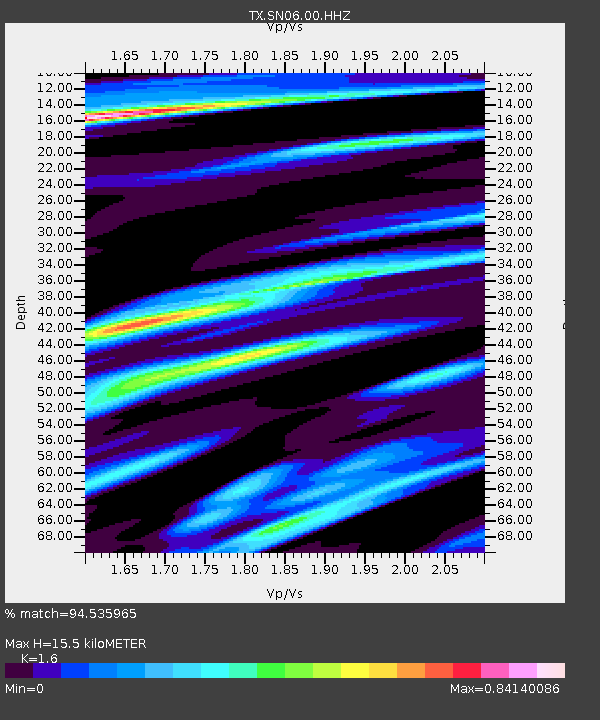
| Estimated Moho Depth: |
15.5 km |
| Estimated Crust Vp/Vs: |
1.60 |
| Assumed Crust Vp: |
6.426 km/s |
| Estimated Crust Vs: |
4.016 km/s |
| Estimated Crust Poisson's Ratio: |
0.18 |
|
| Radial Match: |
94.535965 % |
| Radial Bump: |
398 |
| Transverse Match: |
64.700035 % |
| Transverse Bump: |
400 |
| SOD ConfigId: |
2364251 |
| Insert Time: |
2017-10-22 22:50:52.248 +0000 |
| GWidth: |
2.5 |
| Max Bumps: |
400 |
| Tol: |
0.001 |
|

Signal To Noise
| Channel | StoN | STA | LTA |
| TX:SN06:00:HHZ:20171008T22:43:59.600015Z | 19.30947 | 3.7332275E-6 | 1.9333662E-7 |
| TX:SN06:00:HH1:20171008T22:43:59.600015Z | 3.9378865 | 1.4453319E-6 | 3.6703238E-7 |
| TX:SN06:00:HH2:20171008T22:43:59.600015Z | 4.7559185 | 1.4987866E-6 | 3.1514136E-7 |
| Arrivals |
| Ps | 1.5 SECOND |
| PpPs | 6.0 SECOND |
| PsPs/PpSs | 7.5 SECOND |


