You are here: Home > Network List > NN - Western Great Basin/Eastern Sierra Nevada Stations List
> Station CTC N. Tahoe City Carnelian Bay > Earthquake Result Viewer
CTC N. Tahoe City Carnelian Bay - Earthquake Result Viewer
| Earthquake location: |
Southeast Of Loyalty Islands |
| Earthquake latitude/longitude: |
-23.3/171.6 |
| Earthquake time(UTC): |
2021/02/10 (041) 21:23:59 GMT |
| Earthquake Depth: |
10 km |
| Earthquake Magnitude: |
6.4 mww |
| Earthquake Catalog/Contributor: |
NEIC PDE/us |
|
| Network: |
NN Western Great Basin/Eastern Sierra Nevada |
| Station: |
CTC N. Tahoe City Carnelian Bay |
| Lat/Lon: |
39.21 N/120.13 W |
| Elevation: |
2147 m |
|
| Distance: |
89.0 deg |
| Az: |
46.199 deg |
| Baz: |
238.688 deg |
| Ray Param: |
0.042177994 |
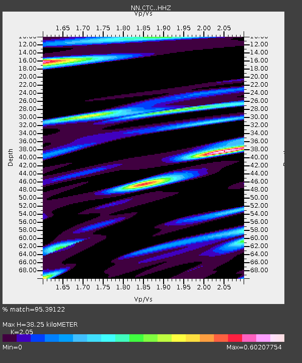
| Estimated Moho Depth: |
38.25 km |
| Estimated Crust Vp/Vs: |
2.05 |
| Assumed Crust Vp: |
6.597 km/s |
| Estimated Crust Vs: |
3.218 km/s |
| Estimated Crust Poisson's Ratio: |
0.34 |
|
| Radial Match: |
95.39122 % |
| Radial Bump: |
291 |
| Transverse Match: |
85.92705 % |
| Transverse Bump: |
400 |
| SOD ConfigId: |
23341671 |
| Insert Time: |
2021-02-24 22:34:42.962 +0000 |
| GWidth: |
2.5 |
| Max Bumps: |
400 |
| Tol: |
0.001 |
|

Signal To Noise
| Channel | StoN | STA | LTA |
| NN:CTC: :HHZ:20210210T21:36:23.09798Z | 2.8592513 | 8.4943883E-7 | 2.9708434E-7 |
| NN:CTC: :HHN:20210210T21:36:23.09798Z | 2.3319776 | 5.486165E-7 | 2.3525806E-7 |
| NN:CTC: :HHE:20210210T21:36:23.09798Z | 2.2500787 | 5.424544E-7 | 2.4108243E-7 |
| Arrivals |
| Ps | 6.2 SECOND |
| PpPs | 17 SECOND |
| PsPs/PpSs | 24 SECOND |


