You are here: Home > Network List > UU - University of Utah Regional Network Stations List
> Station LCMT Little Creek Mountain, UT, USA > Earthquake Result Viewer
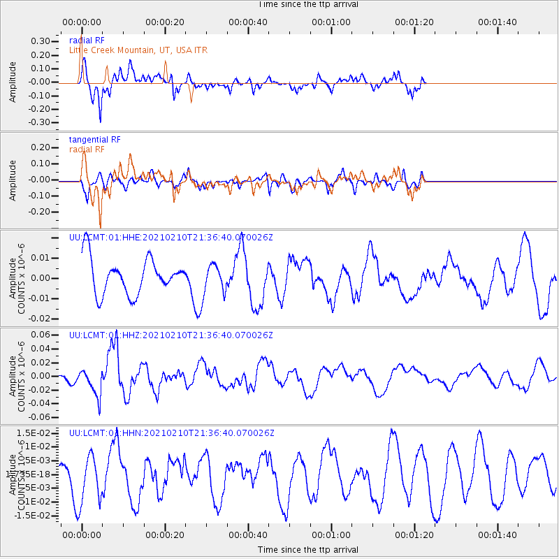
LCMT Little Creek Mountain, UT, USA - Earthquake Result Viewer
*The percent match for this event was below the threshold and hence no stack was calculated.
| Earthquake location: |
Southeast Of Loyalty Islands |
| Earthquake latitude/longitude: |
-23.3/171.6 |
| Earthquake time(UTC): |
2021/02/10 (041) 21:23:59 GMT |
| Earthquake Depth: |
10 km |
| Earthquake Magnitude: |
6.4 mww |
| Earthquake Catalog/Contributor: |
NEIC PDE/us |
|
| Network: |
UU University of Utah Regional Network |
| Station: |
LCMT Little Creek Mountain, UT, USA |
| Lat/Lon: |
37.01 N/113.24 W |
| Elevation: |
1411 m |
|
| Distance: |
92.7 deg |
| Az: |
50.76 deg |
| Baz: |
242.856 deg |
| Ray Param: |
$rayparam |
*The percent match for this event was below the threshold and hence was not used in the summary stack. |
|
| Radial Match: |
77.4689 % |
| Radial Bump: |
400 |
| Transverse Match: |
64.72658 % |
| Transverse Bump: |
400 |
| SOD ConfigId: |
23341671 |
| Insert Time: |
2021-02-24 22:38:34.856 +0000 |
| GWidth: |
2.5 |
| Max Bumps: |
400 |
| Tol: |
0.001 |
|
Signal To Noise
| Channel | StoN | STA | LTA |
| UU:LCMT:01:HHZ:20210210T21:36:40.070026Z | 2.4675612 | 2.0568766E-8 | 8.3356655E-9 |
| UU:LCMT:01:HHN:20210210T21:36:40.070026Z | 2.1413102 | 8.993819E-9 | 4.2001473E-9 |
| UU:LCMT:01:HHE:20210210T21:36:40.070026Z | 0.77888316 | 6.7754953E-9 | 8.698987E-9 |
| Arrivals |
| Ps | |
| PpPs | |
| PsPs/PpSs | |


