You are here: Home > Network List > CI - Caltech Regional Seismic Network Stations List
> Station GMR Granite Mountains Research Center > Earthquake Result Viewer
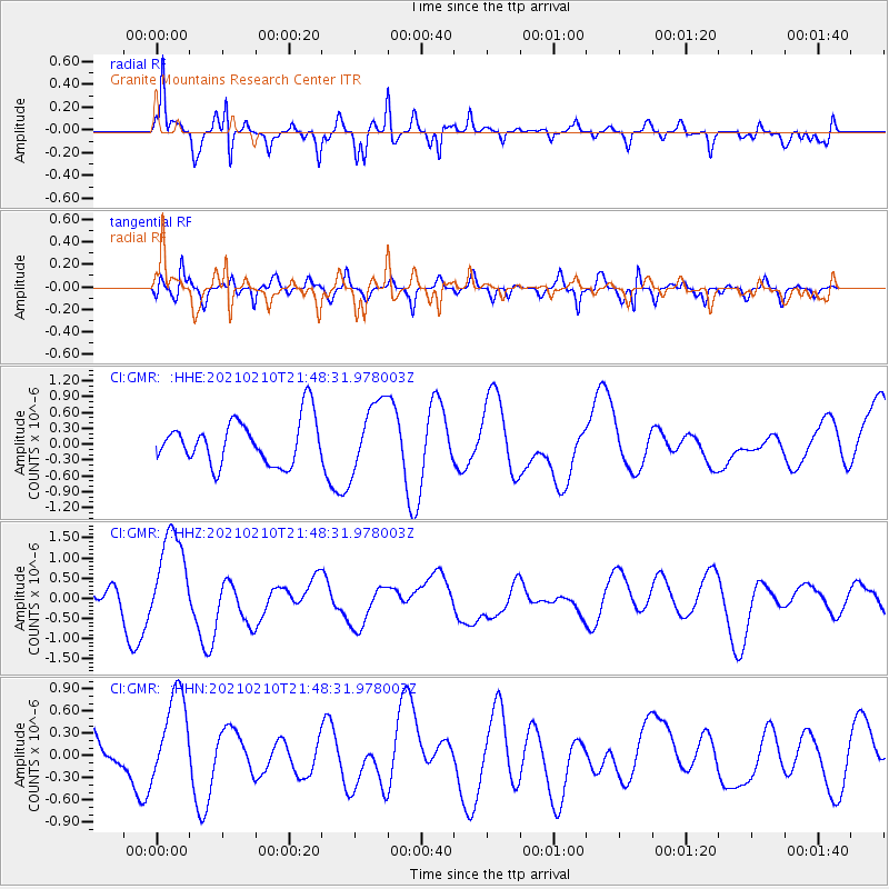
GMR Granite Mountains Research Center - Earthquake Result Viewer
*The percent match for this event was below the threshold and hence no stack was calculated.
| Earthquake location: |
Southeast Of Loyalty Islands |
| Earthquake latitude/longitude: |
-23.5/171.6 |
| Earthquake time(UTC): |
2021/02/10 (041) 21:36:03 GMT |
| Earthquake Depth: |
10 km |
| Earthquake Magnitude: |
5.5 mb |
| Earthquake Catalog/Contributor: |
NEIC PDE/us |
|
| Network: |
CI Caltech Regional Seismic Network |
| Station: |
GMR Granite Mountains Research Center |
| Lat/Lon: |
34.78 N/115.66 W |
| Elevation: |
1326 m |
|
| Distance: |
90.0 deg |
| Az: |
51.82 deg |
| Baz: |
241.278 deg |
| Ray Param: |
$rayparam |
*The percent match for this event was below the threshold and hence was not used in the summary stack. |
|
| Radial Match: |
74.41684 % |
| Radial Bump: |
374 |
| Transverse Match: |
59.180702 % |
| Transverse Bump: |
400 |
| SOD ConfigId: |
23341671 |
| Insert Time: |
2021-02-24 22:45:02.411 +0000 |
| GWidth: |
2.5 |
| Max Bumps: |
400 |
| Tol: |
0.001 |
|
Signal To Noise
| Channel | StoN | STA | LTA |
| CI:GMR: :HHZ:20210210T21:48:31.978003Z | 3.4746726 | 1.1696617E-6 | 3.3662502E-7 |
| CI:GMR: :HHN:20210210T21:48:31.978003Z | 2.1919286 | 6.291349E-7 | 2.8702345E-7 |
| CI:GMR: :HHE:20210210T21:48:31.978003Z | 1.5819266 | 6.637082E-7 | 4.195569E-7 |
| Arrivals |
| Ps | |
| PpPs | |
| PsPs/PpSs | |


