You are here: Home > Network List > CI - Caltech Regional Seismic Network Stations List
> Station TUQ Turquiose Mountain, Baker, CA, USA > Earthquake Result Viewer
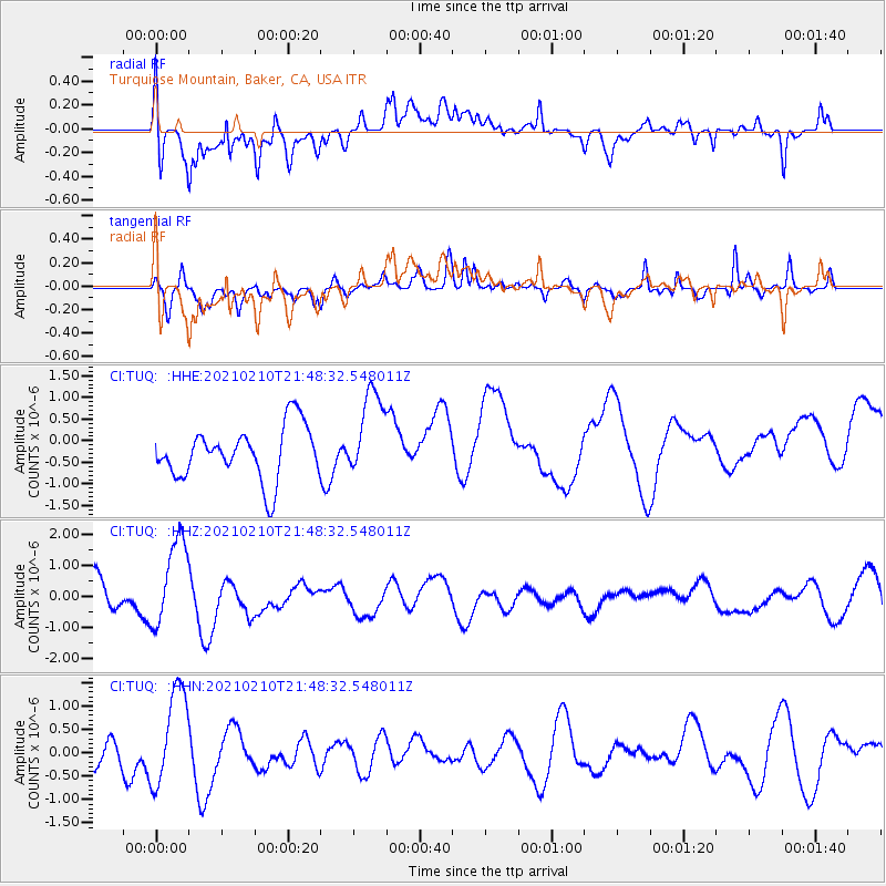
TUQ Turquiose Mountain, Baker, CA, USA - Earthquake Result Viewer
*The percent match for this event was below the threshold and hence no stack was calculated.
| Earthquake location: |
Southeast Of Loyalty Islands |
| Earthquake latitude/longitude: |
-23.5/171.6 |
| Earthquake time(UTC): |
2021/02/10 (041) 21:36:03 GMT |
| Earthquake Depth: |
10 km |
| Earthquake Magnitude: |
5.5 mb |
| Earthquake Catalog/Contributor: |
NEIC PDE/us |
|
| Network: |
CI Caltech Regional Seismic Network |
| Station: |
TUQ Turquiose Mountain, Baker, CA, USA |
| Lat/Lon: |
35.44 N/115.92 W |
| Elevation: |
1350 m |
|
| Distance: |
90.2 deg |
| Az: |
51.146 deg |
| Baz: |
241.128 deg |
| Ray Param: |
$rayparam |
*The percent match for this event was below the threshold and hence was not used in the summary stack. |
|
| Radial Match: |
67.83838 % |
| Radial Bump: |
400 |
| Transverse Match: |
59.715736 % |
| Transverse Bump: |
400 |
| SOD ConfigId: |
23341671 |
| Insert Time: |
2021-02-24 22:45:41.985 +0000 |
| GWidth: |
2.5 |
| Max Bumps: |
400 |
| Tol: |
0.001 |
|
Signal To Noise
| Channel | StoN | STA | LTA |
| CI:TUQ: :HHZ:20210210T21:48:32.548011Z | 3.5849755 | 1.4087709E-6 | 3.929653E-7 |
| CI:TUQ: :HHN:20210210T21:48:32.548011Z | 2.8114908 | 1.0441312E-6 | 3.713799E-7 |
| CI:TUQ: :HHE:20210210T21:48:32.548011Z | 1.684833 | 1.0267383E-6 | 6.094006E-7 |
| Arrivals |
| Ps | |
| PpPs | |
| PsPs/PpSs | |


