You are here: Home > Network List > IU - Global Seismograph Network (GSN - IRIS/USGS) Stations List
> Station COR Corvallis, Oregon, USA > Earthquake Result Viewer
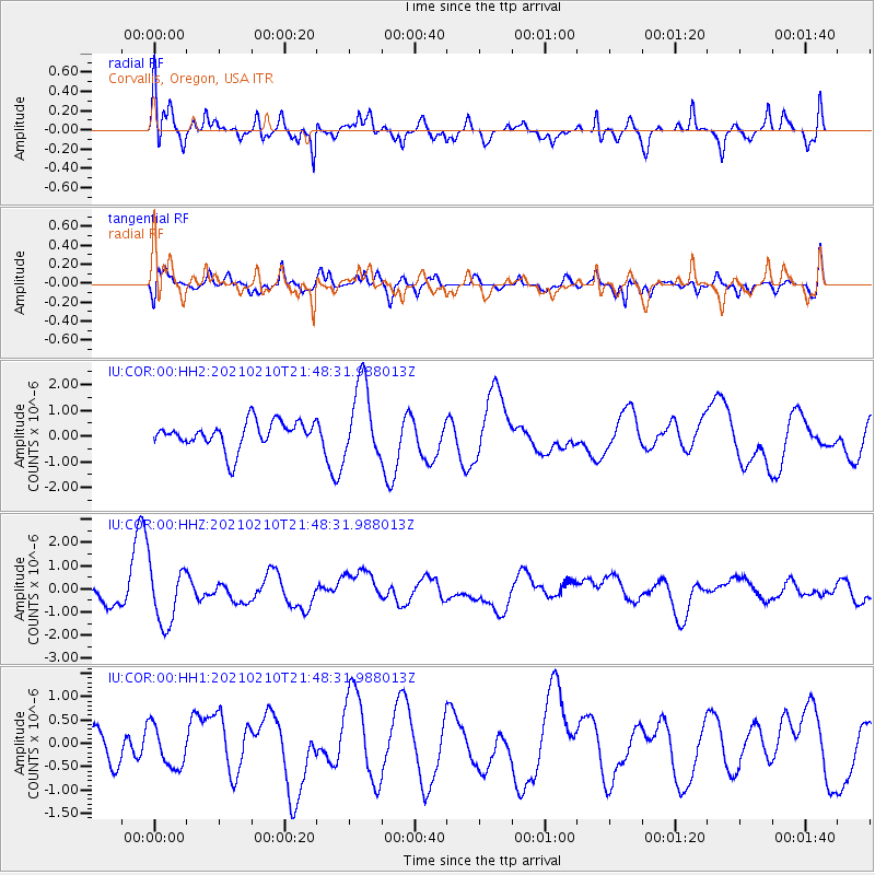
COR Corvallis, Oregon, USA - Earthquake Result Viewer
*The percent match for this event was below the threshold and hence no stack was calculated.
| Earthquake location: |
Southeast Of Loyalty Islands |
| Earthquake latitude/longitude: |
-23.5/171.6 |
| Earthquake time(UTC): |
2021/02/10 (041) 21:36:03 GMT |
| Earthquake Depth: |
10 km |
| Earthquake Magnitude: |
5.5 mb |
| Earthquake Catalog/Contributor: |
NEIC PDE/us |
|
| Network: |
IU Global Seismograph Network (GSN - IRIS/USGS) |
| Station: |
COR Corvallis, Oregon, USA |
| Lat/Lon: |
44.59 N/123.30 W |
| Elevation: |
110 m |
|
| Distance: |
90.0 deg |
| Az: |
40.403 deg |
| Baz: |
236.402 deg |
| Ray Param: |
$rayparam |
*The percent match for this event was below the threshold and hence was not used in the summary stack. |
|
| Radial Match: |
65.898315 % |
| Radial Bump: |
400 |
| Transverse Match: |
50.03687 % |
| Transverse Bump: |
400 |
| SOD ConfigId: |
23341671 |
| Insert Time: |
2021-02-24 22:47:23.794 +0000 |
| GWidth: |
2.5 |
| Max Bumps: |
400 |
| Tol: |
0.001 |
|
Signal To Noise
| Channel | StoN | STA | LTA |
| IU:COR:00:HHZ:20210210T21:48:31.988013Z | 1.8471513 | 1.2268747E-6 | 6.641983E-7 |
| IU:COR:00:HH1:20210210T21:48:31.988013Z | 0.83534676 | 4.4367067E-7 | 5.3112154E-7 |
| IU:COR:00:HH2:20210210T21:48:31.988013Z | 2.8343835 | 1.4703351E-6 | 5.187495E-7 |
| Arrivals |
| Ps | |
| PpPs | |
| PsPs/PpSs | |


