You are here: Home > Network List > US - United States National Seismic Network Stations List
> Station MNTX Cornudas Mountains, Texas, USA > Earthquake Result Viewer
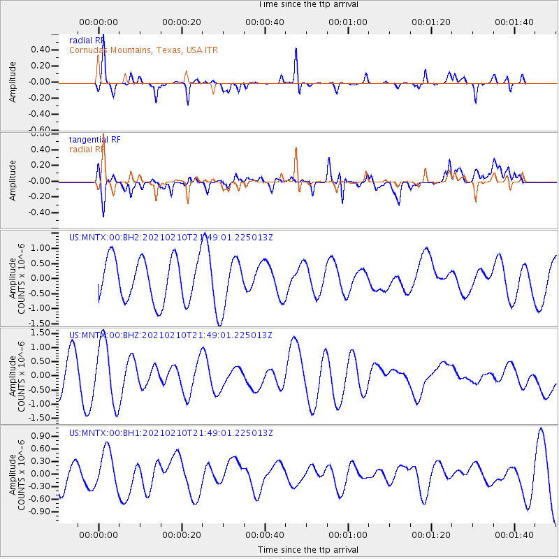
MNTX Cornudas Mountains, Texas, USA - Earthquake Result Viewer
*The percent match for this event was below the threshold and hence no stack was calculated.
| Earthquake location: |
Southeast Of Loyalty Islands |
| Earthquake latitude/longitude: |
-23.5/171.6 |
| Earthquake time(UTC): |
2021/02/10 (041) 21:36:03 GMT |
| Earthquake Depth: |
10 km |
| Earthquake Magnitude: |
5.5 mb |
| Earthquake Catalog/Contributor: |
NEIC PDE/us |
|
| Network: |
US United States National Seismic Network |
| Station: |
MNTX Cornudas Mountains, Texas, USA |
| Lat/Lon: |
31.70 N/105.38 W |
| Elevation: |
404 m |
|
| Distance: |
96.4 deg |
| Az: |
58.37 deg |
| Baz: |
246.527 deg |
| Ray Param: |
$rayparam |
*The percent match for this event was below the threshold and hence was not used in the summary stack. |
|
| Radial Match: |
48.689125 % |
| Radial Bump: |
152 |
| Transverse Match: |
70.70099 % |
| Transverse Bump: |
400 |
| SOD ConfigId: |
23341671 |
| Insert Time: |
2021-02-24 22:51:06.614 +0000 |
| GWidth: |
2.5 |
| Max Bumps: |
400 |
| Tol: |
0.001 |
|
Signal To Noise
| Channel | StoN | STA | LTA |
| US:MNTX:00:BHZ:20210210T21:49:01.225013Z | 2.1931663 | 1.1053801E-6 | 5.040111E-7 |
| US:MNTX:00:BH1:20210210T21:49:01.225013Z | 0.7492785 | 4.9123315E-7 | 6.5560823E-7 |
| US:MNTX:00:BH2:20210210T21:49:01.225013Z | 1.1807181 | 8.327886E-7 | 7.053238E-7 |
| Arrivals |
| Ps | |
| PpPs | |
| PsPs/PpSs | |


