You are here: Home > Network List > US - United States National Seismic Network Stations List
> Station MNTX Cornudas Mountains, Texas, USA > Earthquake Result Viewer
MNTX Cornudas Mountains, Texas, USA - Earthquake Result Viewer
| Earthquake location: |
Rat Islands, Aleutian Islands |
| Earthquake latitude/longitude: |
52.4/176.8 |
| Earthquake time(UTC): |
2017/10/08 (281) 22:34:33 GMT |
| Earthquake Depth: |
112 km |
| Earthquake Magnitude: |
6.6 mww |
| Earthquake Catalog/Contributor: |
NEIC PDE/us |
|
| Network: |
US United States National Seismic Network |
| Station: |
MNTX Cornudas Mountains, Texas, USA |
| Lat/Lon: |
31.70 N/105.38 W |
| Elevation: |
404 m |
|
| Distance: |
58.4 deg |
| Az: |
77.961 deg |
| Baz: |
315.395 deg |
| Ray Param: |
0.06252401 |
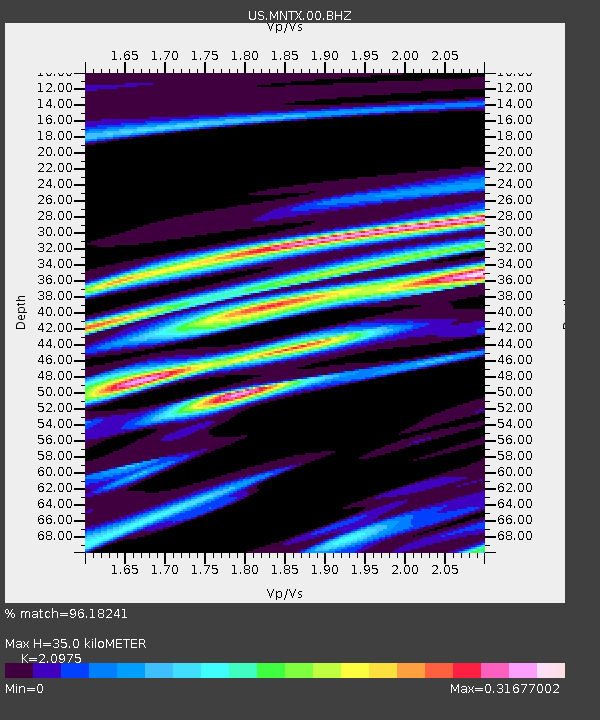
| Estimated Moho Depth: |
35.0 km |
| Estimated Crust Vp/Vs: |
2.10 |
| Assumed Crust Vp: |
6.361 km/s |
| Estimated Crust Vs: |
3.032 km/s |
| Estimated Crust Poisson's Ratio: |
0.35 |
|
| Radial Match: |
96.18241 % |
| Radial Bump: |
344 |
| Transverse Match: |
83.228195 % |
| Transverse Bump: |
400 |
| SOD ConfigId: |
2364251 |
| Insert Time: |
2017-10-22 22:53:16.409 +0000 |
| GWidth: |
2.5 |
| Max Bumps: |
400 |
| Tol: |
0.001 |
|
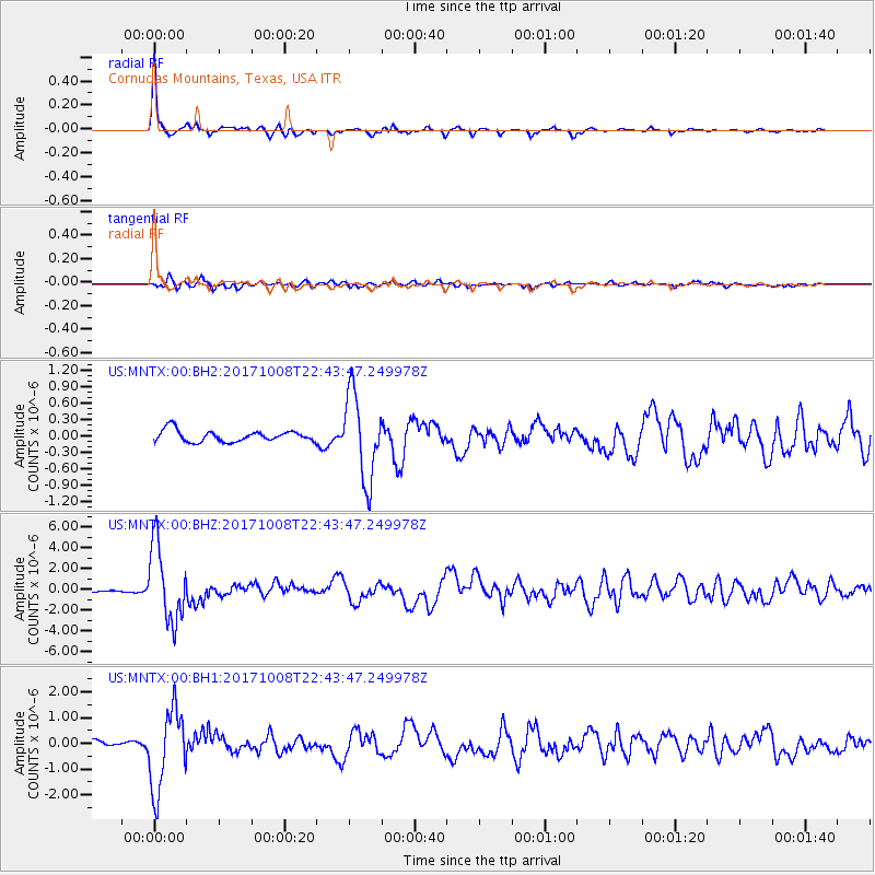
Signal To Noise
| Channel | StoN | STA | LTA |
| US:MNTX:00:BHZ:20171008T22:43:47.249978Z | 40.82416 | 3.6365525E-6 | 8.907844E-8 |
| US:MNTX:00:BH1:20171008T22:43:47.249978Z | 18.026756 | 1.5635891E-6 | 8.673713E-8 |
| US:MNTX:00:BH2:20171008T22:43:47.249978Z | 7.58085 | 7.784367E-7 | 1.02684616E-7 |
| Arrivals |
| Ps | 6.3 SECOND |
| PpPs | 16 SECOND |
| PsPs/PpSs | 23 SECOND |


