You are here: Home > Network List > CI - Caltech Regional Seismic Network Stations List
> Station BAR Barrett, Tecate, CA, USA > Earthquake Result Viewer
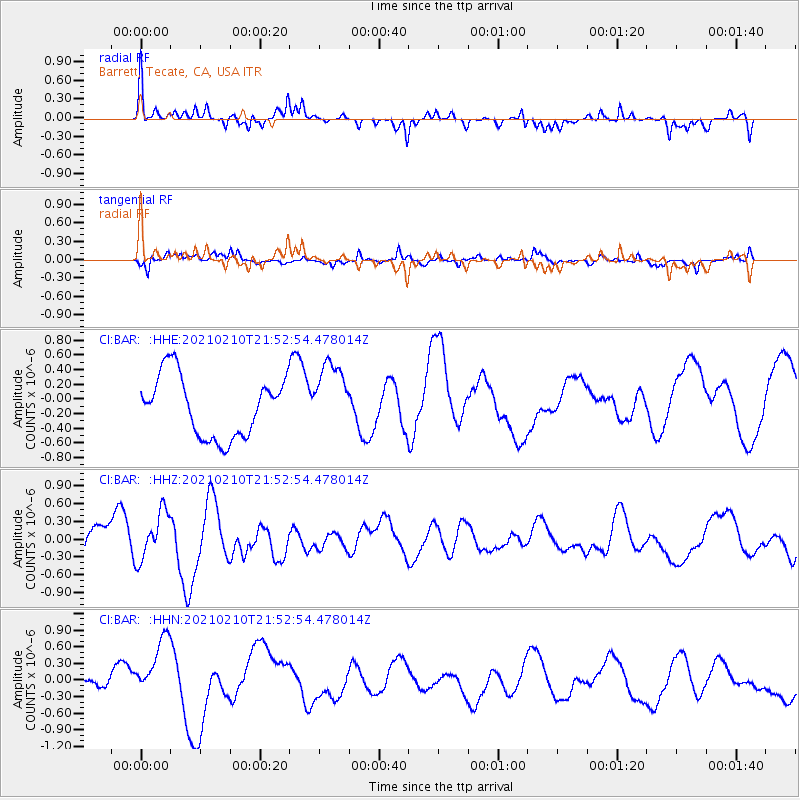
BAR Barrett, Tecate, CA, USA - Earthquake Result Viewer
*The percent match for this event was below the threshold and hence no stack was calculated.
| Earthquake location: |
Southeast Of Loyalty Islands |
| Earthquake latitude/longitude: |
-23.2/171.6 |
| Earthquake time(UTC): |
2021/02/10 (041) 21:40:35 GMT |
| Earthquake Depth: |
10 km |
| Earthquake Magnitude: |
5.6 mb |
| Earthquake Catalog/Contributor: |
NEIC PDE/us |
|
| Network: |
CI Caltech Regional Seismic Network |
| Station: |
BAR Barrett, Tecate, CA, USA |
| Lat/Lon: |
32.68 N/116.67 W |
| Elevation: |
521 m |
|
| Distance: |
88.2 deg |
| Az: |
53.262 deg |
| Baz: |
240.954 deg |
| Ray Param: |
$rayparam |
*The percent match for this event was below the threshold and hence was not used in the summary stack. |
|
| Radial Match: |
56.942726 % |
| Radial Bump: |
369 |
| Transverse Match: |
47.444237 % |
| Transverse Bump: |
270 |
| SOD ConfigId: |
23341671 |
| Insert Time: |
2021-02-24 22:57:12.945 +0000 |
| GWidth: |
2.5 |
| Max Bumps: |
400 |
| Tol: |
0.001 |
|
Signal To Noise
| Channel | StoN | STA | LTA |
| CI:BAR: :HHZ:20210210T21:52:54.478014Z | 1.2480179 | 4.0359805E-7 | 3.2339125E-7 |
| CI:BAR: :HHN:20210210T21:52:54.478014Z | 3.087909 | 5.998116E-7 | 1.9424523E-7 |
| CI:BAR: :HHE:20210210T21:52:54.478014Z | 1.1662962 | 4.8262905E-7 | 4.138134E-7 |
| Arrivals |
| Ps | |
| PpPs | |
| PsPs/PpSs | |


