You are here: Home > Network List > CI - Caltech Regional Seismic Network Stations List
> Station SMM Simmler, CA, USA > Earthquake Result Viewer
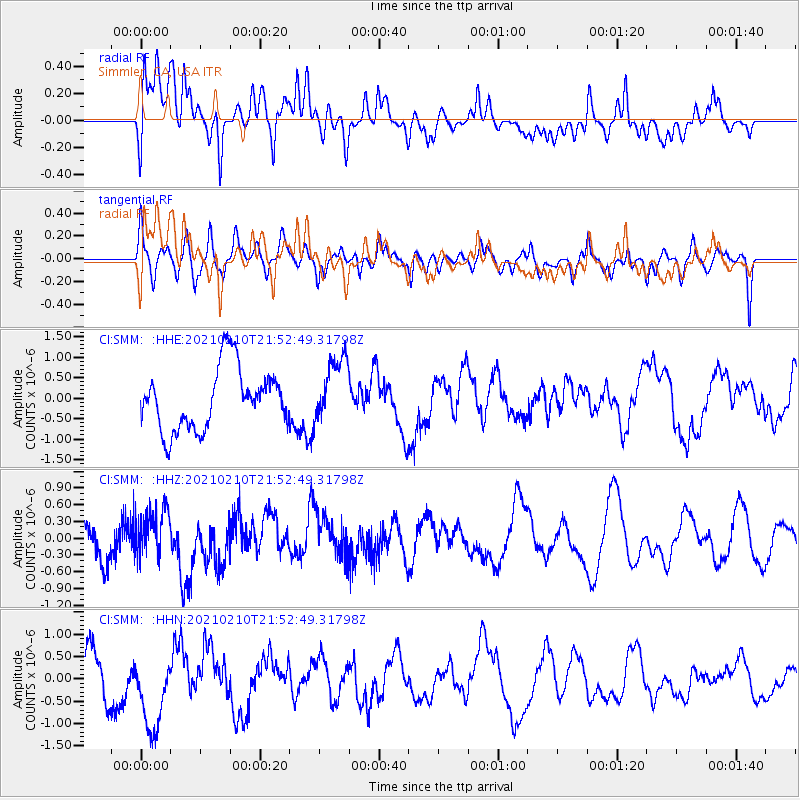
SMM Simmler, CA, USA - Earthquake Result Viewer
*The percent match for this event was below the threshold and hence no stack was calculated.
| Earthquake location: |
Southeast Of Loyalty Islands |
| Earthquake latitude/longitude: |
-23.2/171.6 |
| Earthquake time(UTC): |
2021/02/10 (041) 21:40:35 GMT |
| Earthquake Depth: |
10 km |
| Earthquake Magnitude: |
5.6 mb |
| Earthquake Catalog/Contributor: |
NEIC PDE/us |
|
| Network: |
CI Caltech Regional Seismic Network |
| Station: |
SMM Simmler, CA, USA |
| Lat/Lon: |
35.31 N/120.00 W |
| Elevation: |
599 m |
|
| Distance: |
87.1 deg |
| Az: |
49.603 deg |
| Baz: |
238.951 deg |
| Ray Param: |
$rayparam |
*The percent match for this event was below the threshold and hence was not used in the summary stack. |
|
| Radial Match: |
49.347603 % |
| Radial Bump: |
400 |
| Transverse Match: |
49.684494 % |
| Transverse Bump: |
400 |
| SOD ConfigId: |
23341671 |
| Insert Time: |
2021-02-24 22:58:04.266 +0000 |
| GWidth: |
2.5 |
| Max Bumps: |
400 |
| Tol: |
0.001 |
|
Signal To Noise
| Channel | StoN | STA | LTA |
| CI:SMM: :HHZ:20210210T21:52:49.31798Z | 1.2658566 | 3.9694172E-7 | 3.1357558E-7 |
| CI:SMM: :HHN:20210210T21:52:49.31798Z | 1.8643494 | 8.564147E-7 | 4.5936386E-7 |
| CI:SMM: :HHE:20210210T21:52:49.31798Z | 1.0660615 | 7.9359967E-7 | 7.44422E-7 |
| Arrivals |
| Ps | |
| PpPs | |
| PsPs/PpSs | |


