You are here: Home > Network List > TA - USArray Transportable Network (new EarthScope stations) Stations List
> Station O17K Koliganek, Bristol Bay, AK, USA > Earthquake Result Viewer
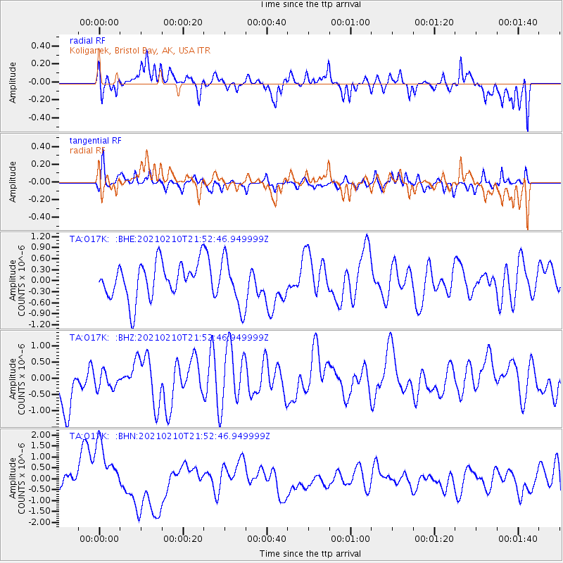
O17K Koliganek, Bristol Bay, AK, USA - Earthquake Result Viewer
*The percent match for this event was below the threshold and hence no stack was calculated.
| Earthquake location: |
Southeast Of Loyalty Islands |
| Earthquake latitude/longitude: |
-23.2/171.6 |
| Earthquake time(UTC): |
2021/02/10 (041) 21:40:35 GMT |
| Earthquake Depth: |
10 km |
| Earthquake Magnitude: |
5.6 mb |
| Earthquake Catalog/Contributor: |
NEIC PDE/us |
|
| Network: |
TA USArray Transportable Network (new EarthScope stations) |
| Station: |
O17K Koliganek, Bristol Bay, AK, USA |
| Lat/Lon: |
59.77 N/157.09 W |
| Elevation: |
156 m |
|
| Distance: |
86.6 deg |
| Az: |
15.284 deg |
| Baz: |
208.641 deg |
| Ray Param: |
$rayparam |
*The percent match for this event was below the threshold and hence was not used in the summary stack. |
|
| Radial Match: |
53.99299 % |
| Radial Bump: |
400 |
| Transverse Match: |
54.636276 % |
| Transverse Bump: |
289 |
| SOD ConfigId: |
23341671 |
| Insert Time: |
2021-02-24 23:02:10.499 +0000 |
| GWidth: |
2.5 |
| Max Bumps: |
400 |
| Tol: |
0.001 |
|
Signal To Noise
| Channel | StoN | STA | LTA |
| TA:O17K: :BHZ:20210210T21:52:46.949999Z | 0.4870261 | 2.8361643E-7 | 5.823434E-7 |
| TA:O17K: :BHN:20210210T21:52:46.949999Z | 2.497523 | 1.3495833E-6 | 5.4036866E-7 |
| TA:O17K: :BHE:20210210T21:52:46.949999Z | 1.4284357 | 6.8852876E-7 | 4.8201593E-7 |
| Arrivals |
| Ps | |
| PpPs | |
| PsPs/PpSs | |


