You are here: Home > Network List > US - United States National Seismic Network Stations List
> Station OXF Oxford, Mississippi, USA > Earthquake Result Viewer
OXF Oxford, Mississippi, USA - Earthquake Result Viewer
| Earthquake location: |
Rat Islands, Aleutian Islands |
| Earthquake latitude/longitude: |
52.4/176.8 |
| Earthquake time(UTC): |
2017/10/08 (281) 22:34:33 GMT |
| Earthquake Depth: |
112 km |
| Earthquake Magnitude: |
6.6 mww |
| Earthquake Catalog/Contributor: |
NEIC PDE/us |
|
| Network: |
US United States National Seismic Network |
| Station: |
OXF Oxford, Mississippi, USA |
| Lat/Lon: |
34.51 N/89.41 W |
| Elevation: |
101 m |
|
| Distance: |
65.6 deg |
| Az: |
64.77 deg |
| Baz: |
317.898 deg |
| Ray Param: |
0.05784583 |
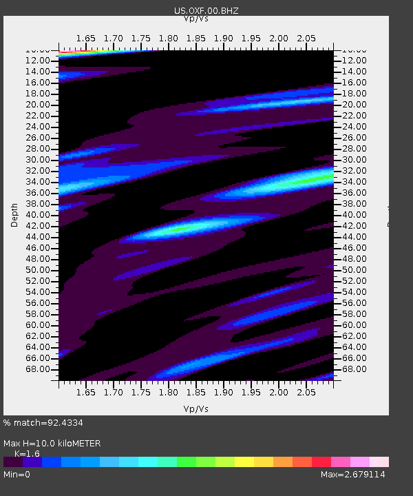
| Estimated Moho Depth: |
10.0 km |
| Estimated Crust Vp/Vs: |
1.60 |
| Assumed Crust Vp: |
6.38 km/s |
| Estimated Crust Vs: |
3.988 km/s |
| Estimated Crust Poisson's Ratio: |
0.18 |
|
| Radial Match: |
92.4334 % |
| Radial Bump: |
330 |
| Transverse Match: |
90.34946 % |
| Transverse Bump: |
392 |
| SOD ConfigId: |
2364251 |
| Insert Time: |
2017-10-22 22:53:53.196 +0000 |
| GWidth: |
2.5 |
| Max Bumps: |
400 |
| Tol: |
0.001 |
|
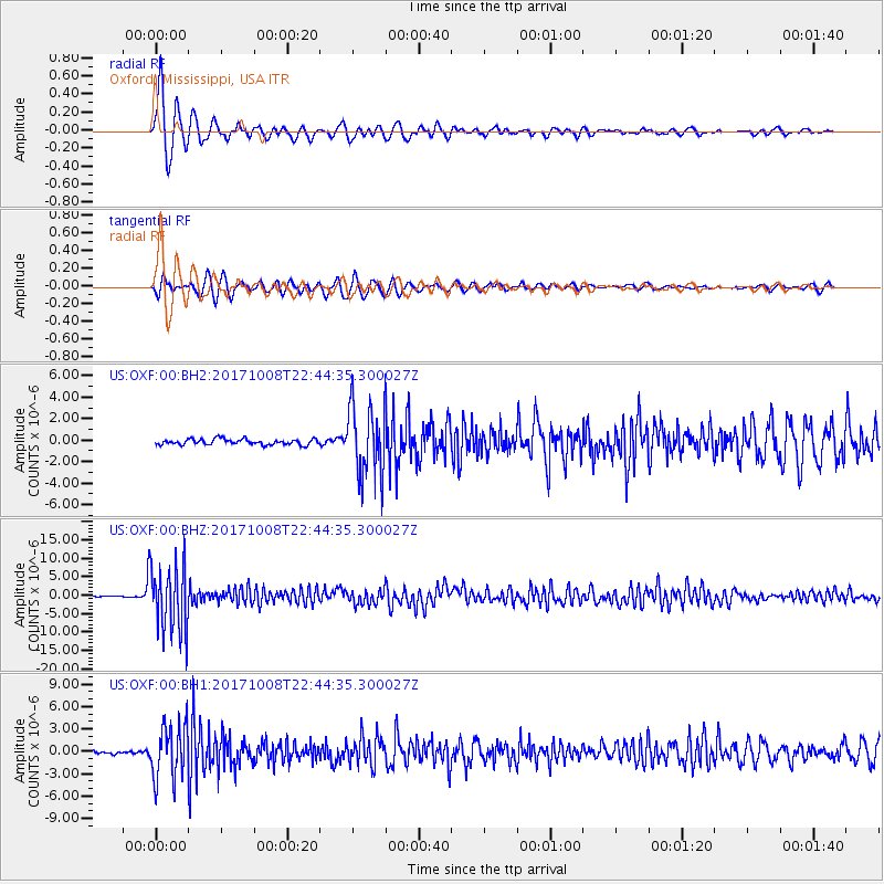
Signal To Noise
| Channel | StoN | STA | LTA |
| US:OXF:00:BHZ:20171008T22:44:35.300027Z | 74.22911 | 9.115523E-6 | 1.2280255E-7 |
| US:OXF:00:BH1:20171008T22:44:35.300027Z | 10.515944 | 3.6595168E-6 | 3.47997E-7 |
| US:OXF:00:BH2:20171008T22:44:35.300027Z | 12.492419 | 3.2951511E-6 | 2.6377205E-7 |
| Arrivals |
| Ps | 1.0 SECOND |
| PpPs | 3.9 SECOND |
| PsPs/PpSs | 4.9 SECOND |


