You are here: Home > Network List > CI - Caltech Regional Seismic Network Stations List
> Station SWS Sam W. Stewart, Westmorland, CA, USA > Earthquake Result Viewer
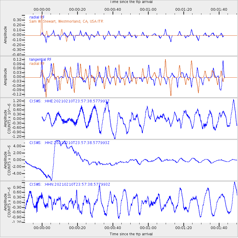
SWS Sam W. Stewart, Westmorland, CA, USA - Earthquake Result Viewer
*The percent match for this event was below the threshold and hence no stack was calculated.
| Earthquake location: |
Southeast Of Loyalty Islands |
| Earthquake latitude/longitude: |
-23.2/171.7 |
| Earthquake time(UTC): |
2021/02/10 (041) 23:45:15 GMT |
| Earthquake Depth: |
10 km |
| Earthquake Magnitude: |
5.9 mww |
| Earthquake Catalog/Contributor: |
NEIC PDE/us |
|
| Network: |
CI Caltech Regional Seismic Network |
| Station: |
SWS Sam W. Stewart, Westmorland, CA, USA |
| Lat/Lon: |
32.94 N/115.80 W |
| Elevation: |
140 m |
|
| Distance: |
88.9 deg |
| Az: |
53.355 deg |
| Baz: |
241.388 deg |
| Ray Param: |
$rayparam |
*The percent match for this event was below the threshold and hence was not used in the summary stack. |
|
| Radial Match: |
51.721287 % |
| Radial Bump: |
400 |
| Transverse Match: |
69.106064 % |
| Transverse Bump: |
400 |
| SOD ConfigId: |
23341671 |
| Insert Time: |
2021-02-25 00:52:25.867 +0000 |
| GWidth: |
2.5 |
| Max Bumps: |
400 |
| Tol: |
0.001 |
|
Signal To Noise
| Channel | StoN | STA | LTA |
| CI:SWS: :HHZ:20210210T23:57:38.577993Z | 4.5455813 | 3.3899075E-6 | 7.457589E-7 |
| CI:SWS: :HHN:20210210T23:57:38.577993Z | 0.80614036 | 2.691881E-7 | 3.3392212E-7 |
| CI:SWS: :HHE:20210210T23:57:38.577993Z | 2.1914542 | 6.394092E-7 | 2.9177394E-7 |
| Arrivals |
| Ps | |
| PpPs | |
| PsPs/PpSs | |


