You are here: Home > Network List > UU - University of Utah Regional Network Stations List
> Station FOR2 Blundell East, UT, USA > Earthquake Result Viewer
FOR2 Blundell East, UT, USA - Earthquake Result Viewer
| Earthquake location: |
Rat Islands, Aleutian Islands |
| Earthquake latitude/longitude: |
52.4/176.8 |
| Earthquake time(UTC): |
2017/10/08 (281) 22:34:33 GMT |
| Earthquake Depth: |
112 km |
| Earthquake Magnitude: |
6.6 mww |
| Earthquake Catalog/Contributor: |
NEIC PDE/us |
|
| Network: |
UU University of Utah Regional Network |
| Station: |
FOR2 Blundell East, UT, USA |
| Lat/Lon: |
38.49 N/112.87 W |
| Elevation: |
1760 m |
|
| Distance: |
49.3 deg |
| Az: |
77.013 deg |
| Baz: |
310.535 deg |
| Ray Param: |
0.06841572 |
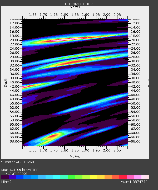
| Estimated Moho Depth: |
19.5 km |
| Estimated Crust Vp/Vs: |
1.81 |
| Assumed Crust Vp: |
6.276 km/s |
| Estimated Crust Vs: |
3.467 km/s |
| Estimated Crust Poisson's Ratio: |
0.28 |
|
| Radial Match: |
83.13268 % |
| Radial Bump: |
400 |
| Transverse Match: |
61.553806 % |
| Transverse Bump: |
400 |
| SOD ConfigId: |
2364251 |
| Insert Time: |
2017-10-22 22:54:33.091 +0000 |
| GWidth: |
2.5 |
| Max Bumps: |
400 |
| Tol: |
0.001 |
|

Signal To Noise
| Channel | StoN | STA | LTA |
| UU:FOR2:01:HHZ:20171008T22:42:41.109994Z | 8.945354 | 8.405856E-8 | 9.396896E-9 |
| UU:FOR2:01:HHN:20171008T22:42:41.109994Z | 4.44465 | 4.35866E-8 | 9.806532E-9 |
| UU:FOR2:01:HHE:20171008T22:42:41.109994Z | 4.1362853 | 4.5350138E-8 | 1.0963977E-8 |
| Arrivals |
| Ps | 2.7 SECOND |
| PpPs | 8.3 SECOND |
| PsPs/PpSs | 11 SECOND |


