You are here: Home > Network List > UU - University of Utah Regional Network Stations List
> Station MPU Maple Canyon, UT, USA > Earthquake Result Viewer
MPU Maple Canyon, UT, USA - Earthquake Result Viewer
| Earthquake location: |
Rat Islands, Aleutian Islands |
| Earthquake latitude/longitude: |
52.4/176.8 |
| Earthquake time(UTC): |
2017/10/08 (281) 22:34:33 GMT |
| Earthquake Depth: |
112 km |
| Earthquake Magnitude: |
6.6 mww |
| Earthquake Catalog/Contributor: |
NEIC PDE/us |
|
| Network: |
UU University of Utah Regional Network |
| Station: |
MPU Maple Canyon, UT, USA |
| Lat/Lon: |
40.02 N/111.63 W |
| Elevation: |
1909 m |
|
| Distance: |
49.1 deg |
| Az: |
74.66 deg |
| Baz: |
309.778 deg |
| Ray Param: |
0.06856965 |
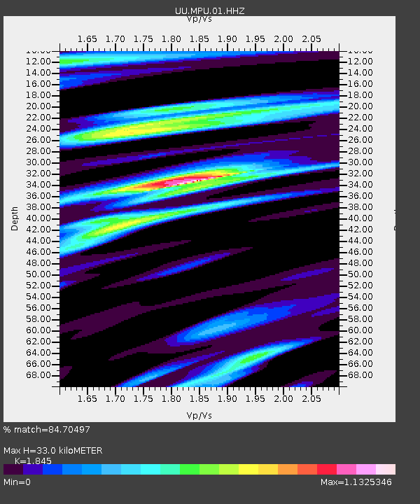
| Estimated Moho Depth: |
33.0 km |
| Estimated Crust Vp/Vs: |
1.85 |
| Assumed Crust Vp: |
6.155 km/s |
| Estimated Crust Vs: |
3.336 km/s |
| Estimated Crust Poisson's Ratio: |
0.29 |
|
| Radial Match: |
84.70497 % |
| Radial Bump: |
400 |
| Transverse Match: |
74.62883 % |
| Transverse Bump: |
400 |
| SOD ConfigId: |
2364251 |
| Insert Time: |
2017-10-22 22:54:56.177 +0000 |
| GWidth: |
2.5 |
| Max Bumps: |
400 |
| Tol: |
0.001 |
|

Signal To Noise
| Channel | StoN | STA | LTA |
| UU:MPU:01:HHZ:20171008T22:42:39.255013Z | 12.513712 | 1.2029616E-7 | 9.613148E-9 |
| UU:MPU:01:HHN:20171008T22:42:39.255013Z | 5.668806 | 3.9535543E-8 | 6.9742274E-9 |
| UU:MPU:01:HHE:20171008T22:42:39.255013Z | 8.792858 | 4.1026787E-8 | 4.6659214E-9 |
| Arrivals |
| Ps | 4.8 SECOND |
| PpPs | 14 SECOND |
| PsPs/PpSs | 19 SECOND |


