You are here: Home > Network List > TA - USArray Transportable Network (new EarthScope stations) Stations List
> Station I17K Unalakleet, AK, USA > Earthquake Result Viewer
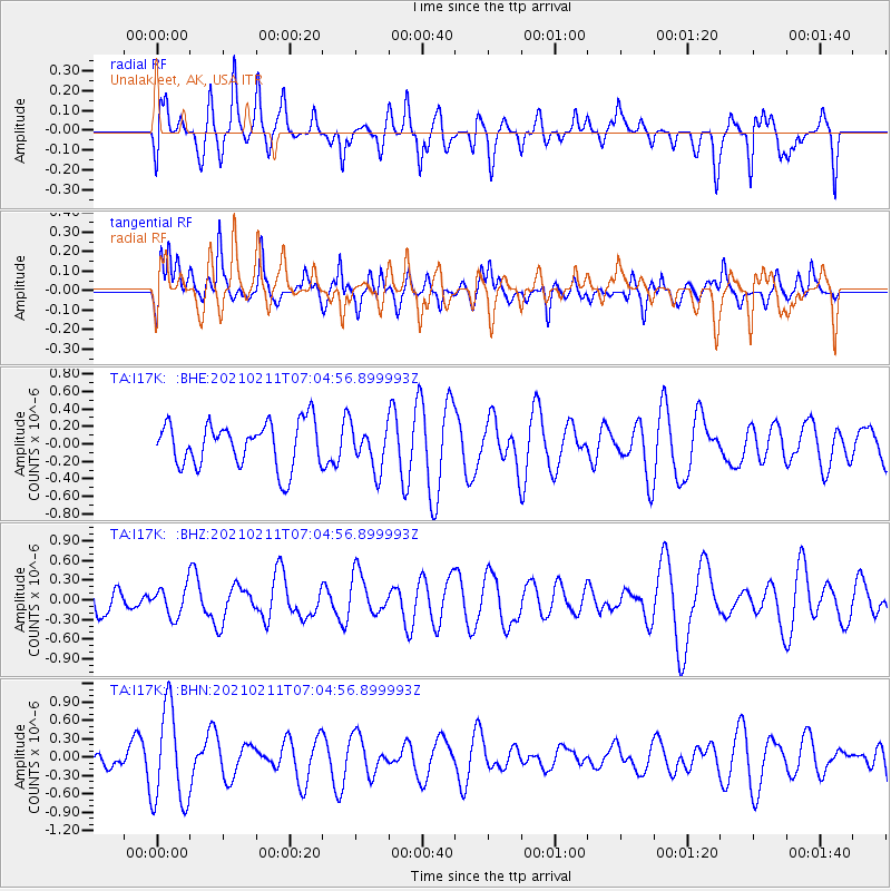
I17K Unalakleet, AK, USA - Earthquake Result Viewer
*The percent match for this event was below the threshold and hence no stack was calculated.
| Earthquake location: |
Southeast Of Loyalty Islands |
| Earthquake latitude/longitude: |
-23.3/171.7 |
| Earthquake time(UTC): |
2021/02/11 (042) 06:52:30 GMT |
| Earthquake Depth: |
10 km |
| Earthquake Magnitude: |
6.0 Mww |
| Earthquake Catalog/Contributor: |
NEIC PDE/us |
|
| Network: |
TA USArray Transportable Network (new EarthScope stations) |
| Station: |
I17K Unalakleet, AK, USA |
| Lat/Lon: |
63.89 N/160.70 W |
| Elevation: |
105 m |
|
| Distance: |
89.5 deg |
| Az: |
11.827 deg |
| Baz: |
205.203 deg |
| Ray Param: |
$rayparam |
*The percent match for this event was below the threshold and hence was not used in the summary stack. |
|
| Radial Match: |
55.912926 % |
| Radial Bump: |
393 |
| Transverse Match: |
47.83949 % |
| Transverse Bump: |
400 |
| SOD ConfigId: |
23341671 |
| Insert Time: |
2021-02-25 08:04:08.015 +0000 |
| GWidth: |
2.5 |
| Max Bumps: |
400 |
| Tol: |
0.001 |
|
Signal To Noise
| Channel | StoN | STA | LTA |
| TA:I17K: :BHZ:20210211T07:04:56.899993Z | 1.0876495 | 2.2569257E-7 | 2.0750487E-7 |
| TA:I17K: :BHN:20210211T07:04:56.899993Z | 4.1827474 | 7.907421E-7 | 1.8904849E-7 |
| TA:I17K: :BHE:20210211T07:04:56.899993Z | 0.96484816 | 2.4622136E-7 | 2.5519182E-7 |
| Arrivals |
| Ps | |
| PpPs | |
| PsPs/PpSs | |


