You are here: Home > Network List > UU - University of Utah Regional Network Stations List
> Station KNB Kanab, UT, USA > Earthquake Result Viewer
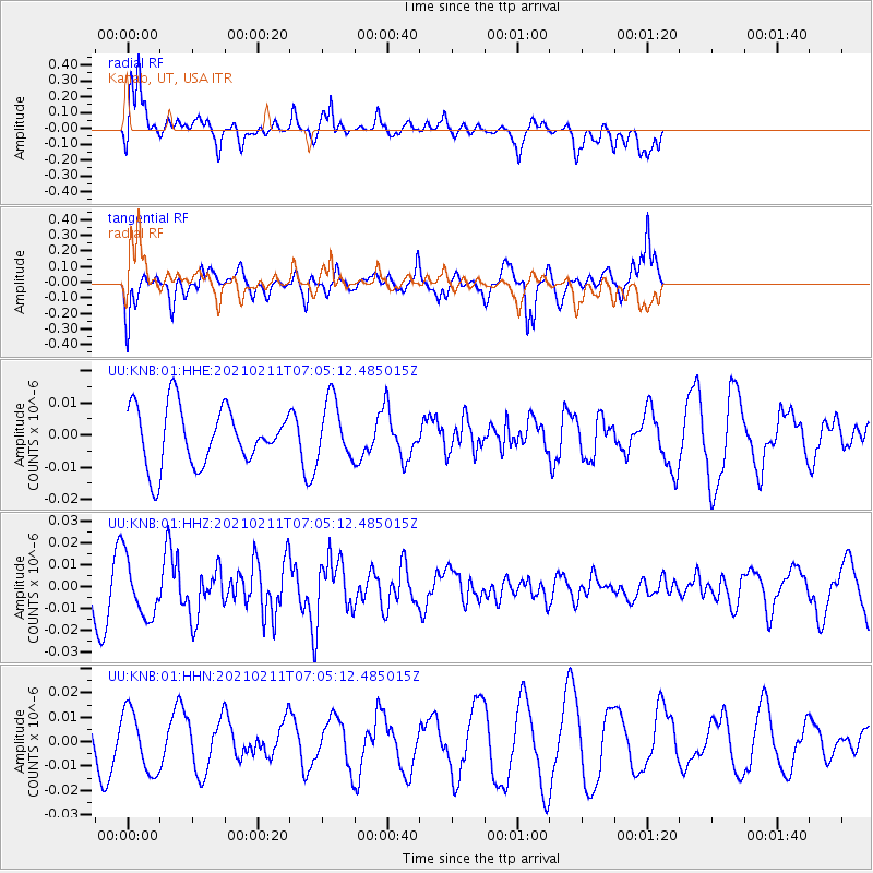
KNB Kanab, UT, USA - Earthquake Result Viewer
*The percent match for this event was below the threshold and hence no stack was calculated.
| Earthquake location: |
Southeast Of Loyalty Islands |
| Earthquake latitude/longitude: |
-23.3/171.7 |
| Earthquake time(UTC): |
2021/02/11 (042) 06:52:30 GMT |
| Earthquake Depth: |
10 km |
| Earthquake Magnitude: |
6.0 Mww |
| Earthquake Catalog/Contributor: |
NEIC PDE/us |
|
| Network: |
UU University of Utah Regional Network |
| Station: |
KNB Kanab, UT, USA |
| Lat/Lon: |
37.02 N/112.82 W |
| Elevation: |
1715 m |
|
| Distance: |
92.9 deg |
| Az: |
50.876 deg |
| Baz: |
243.015 deg |
| Ray Param: |
$rayparam |
*The percent match for this event was below the threshold and hence was not used in the summary stack. |
|
| Radial Match: |
74.02122 % |
| Radial Bump: |
400 |
| Transverse Match: |
64.27904 % |
| Transverse Bump: |
394 |
| SOD ConfigId: |
23341671 |
| Insert Time: |
2021-02-25 08:05:33.653 +0000 |
| GWidth: |
2.5 |
| Max Bumps: |
400 |
| Tol: |
0.001 |
|
Signal To Noise
| Channel | StoN | STA | LTA |
| UU:KNB:01:HHZ:20210211T07:05:12.485015Z | 1.5391703 | 1.3445627E-8 | 8.7356335E-9 |
| UU:KNB:01:HHN:20210211T07:05:12.485015Z | 1.7967383 | 1.254299E-8 | 6.980978E-9 |
| UU:KNB:01:HHE:20210211T07:05:12.485015Z | 1.0174725 | 9.157332E-9 | 9.000078E-9 |
| Arrivals |
| Ps | |
| PpPs | |
| PsPs/PpSs | |


