You are here: Home > Network List > WY - Yellowstone Wyoming Seismic Network Stations List
> Station YNR Norris Junction, YNP, WY, USA > Earthquake Result Viewer
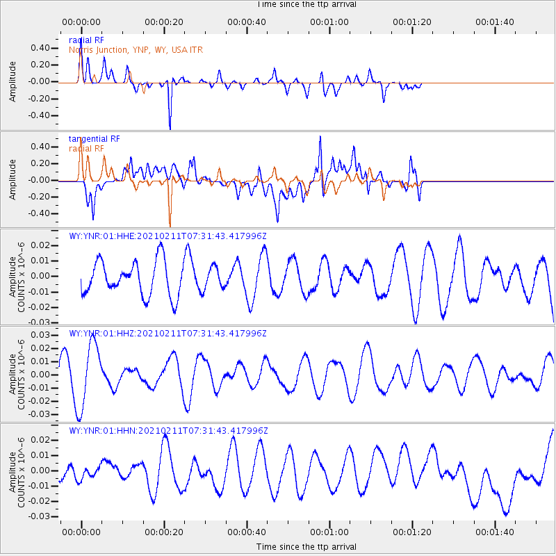
YNR Norris Junction, YNP, WY, USA - Earthquake Result Viewer
*The percent match for this event was below the threshold and hence no stack was calculated.
| Earthquake location: |
Southeast Of Loyalty Islands |
| Earthquake latitude/longitude: |
-23.3/171.9 |
| Earthquake time(UTC): |
2021/02/11 (042) 07:18:40 GMT |
| Earthquake Depth: |
10 km |
| Earthquake Magnitude: |
5.5 Mww |
| Earthquake Catalog/Contributor: |
NEIC PDE/us |
|
| Network: |
WY Yellowstone Wyoming Seismic Network |
| Station: |
YNR Norris Junction, YNP, WY, USA |
| Lat/Lon: |
44.72 N/110.68 W |
| Elevation: |
2336 m |
|
| Distance: |
97.6 deg |
| Az: |
44.588 deg |
| Baz: |
244.88 deg |
| Ray Param: |
$rayparam |
*The percent match for this event was below the threshold and hence was not used in the summary stack. |
|
| Radial Match: |
75.70745 % |
| Radial Bump: |
290 |
| Transverse Match: |
51.52725 % |
| Transverse Bump: |
400 |
| SOD ConfigId: |
23341671 |
| Insert Time: |
2021-02-25 08:32:44.853 +0000 |
| GWidth: |
2.5 |
| Max Bumps: |
400 |
| Tol: |
0.001 |
|
Signal To Noise
| Channel | StoN | STA | LTA |
| WY:YNR:01:HHZ:20210211T07:31:43.417996Z | 2.2938395 | 2.4708452E-8 | 1.07716565E-8 |
| WY:YNR:01:HHN:20210211T07:31:43.417996Z | 0.60779893 | 3.795124E-9 | 6.2440453E-9 |
| WY:YNR:01:HHE:20210211T07:31:43.417996Z | 0.654221 | 7.179919E-9 | 1.09747615E-8 |
| Arrivals |
| Ps | |
| PpPs | |
| PsPs/PpSs | |


