You are here: Home > Network List > UO - University of Oregon Regional Network Stations List
> Station DRAN Drain, OR, USA > Earthquake Result Viewer
DRAN Drain, OR, USA - Earthquake Result Viewer
| Earthquake location: |
Southeast Of Loyalty Islands |
| Earthquake latitude/longitude: |
-22.8/171.8 |
| Earthquake time(UTC): |
2021/02/11 (042) 07:23:06 GMT |
| Earthquake Depth: |
10 km |
| Earthquake Magnitude: |
5.5 mb |
| Earthquake Catalog/Contributor: |
NEIC PDE/us |
|
| Network: |
UO University of Oregon Regional Network |
| Station: |
DRAN Drain, OR, USA |
| Lat/Lon: |
43.70 N/123.35 W |
| Elevation: |
141 m |
|
| Distance: |
88.9 deg |
| Az: |
41.046 deg |
| Baz: |
236.631 deg |
| Ray Param: |
0.04222104 |
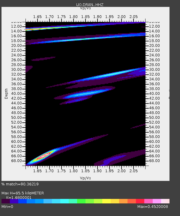
| Estimated Moho Depth: |
65.5 km |
| Estimated Crust Vp/Vs: |
1.68 |
| Assumed Crust Vp: |
6.522 km/s |
| Estimated Crust Vs: |
3.882 km/s |
| Estimated Crust Poisson's Ratio: |
0.23 |
|
| Radial Match: |
90.36219 % |
| Radial Bump: |
331 |
| Transverse Match: |
65.50861 % |
| Transverse Bump: |
400 |
| SOD ConfigId: |
23341671 |
| Insert Time: |
2021-02-25 08:42:58.005 +0000 |
| GWidth: |
2.5 |
| Max Bumps: |
400 |
| Tol: |
0.001 |
|

Signal To Noise
| Channel | StoN | STA | LTA |
| UO:DRAN: :HHZ:20210211T07:35:29.409975Z | 2.2046568 | 8.826145E-7 | 4.0034098E-7 |
| UO:DRAN: :HHN:20210211T07:35:29.409975Z | 0.83290094 | 2.1727492E-7 | 2.6086525E-7 |
| UO:DRAN: :HHE:20210211T07:35:29.409975Z | 1.2512258 | 2.688356E-7 | 2.1485779E-7 |
| Arrivals |
| Ps | 7.0 SECOND |
| PpPs | 26 SECOND |
| PsPs/PpSs | 33 SECOND |


