You are here: Home > Network List > US - United States National Seismic Network Stations List
> Station TPNV Topopah Spring, Nevada, USA > Earthquake Result Viewer
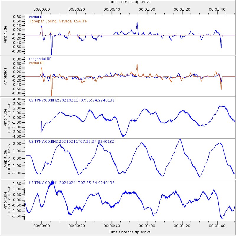
TPNV Topopah Spring, Nevada, USA - Earthquake Result Viewer
*The percent match for this event was below the threshold and hence no stack was calculated.
| Earthquake location: |
Southeast Of Loyalty Islands |
| Earthquake latitude/longitude: |
-22.8/171.8 |
| Earthquake time(UTC): |
2021/02/11 (042) 07:23:06 GMT |
| Earthquake Depth: |
10 km |
| Earthquake Magnitude: |
5.5 mb |
| Earthquake Catalog/Contributor: |
NEIC PDE/us |
|
| Network: |
US United States National Seismic Network |
| Station: |
TPNV Topopah Spring, Nevada, USA |
| Lat/Lon: |
36.95 N/116.25 W |
| Elevation: |
1600 m |
|
| Distance: |
90.1 deg |
| Az: |
49.612 deg |
| Baz: |
241.289 deg |
| Ray Param: |
$rayparam |
*The percent match for this event was below the threshold and hence was not used in the summary stack. |
|
| Radial Match: |
86.437744 % |
| Radial Bump: |
400 |
| Transverse Match: |
51.635593 % |
| Transverse Bump: |
400 |
| SOD ConfigId: |
23341671 |
| Insert Time: |
2021-02-25 08:43:23.534 +0000 |
| GWidth: |
2.5 |
| Max Bumps: |
400 |
| Tol: |
0.001 |
|
Signal To Noise
| Channel | StoN | STA | LTA |
| US:TPNV:00:BHZ:20210211T07:35:34.924013Z | 1.2515144 | 1.2957695E-6 | 1.0353613E-6 |
| US:TPNV:00:BH1:20210211T07:35:34.924013Z | 1.4754907 | 9.420405E-7 | 6.3845914E-7 |
| US:TPNV:00:BH2:20210211T07:35:34.924013Z | 0.61745435 | 5.769952E-7 | 9.3447426E-7 |
| Arrivals |
| Ps | |
| PpPs | |
| PsPs/PpSs | |


