You are here: Home > Network List > G - GEOSCOPE Stations List
> Station INU Inuyama, Japan > Earthquake Result Viewer
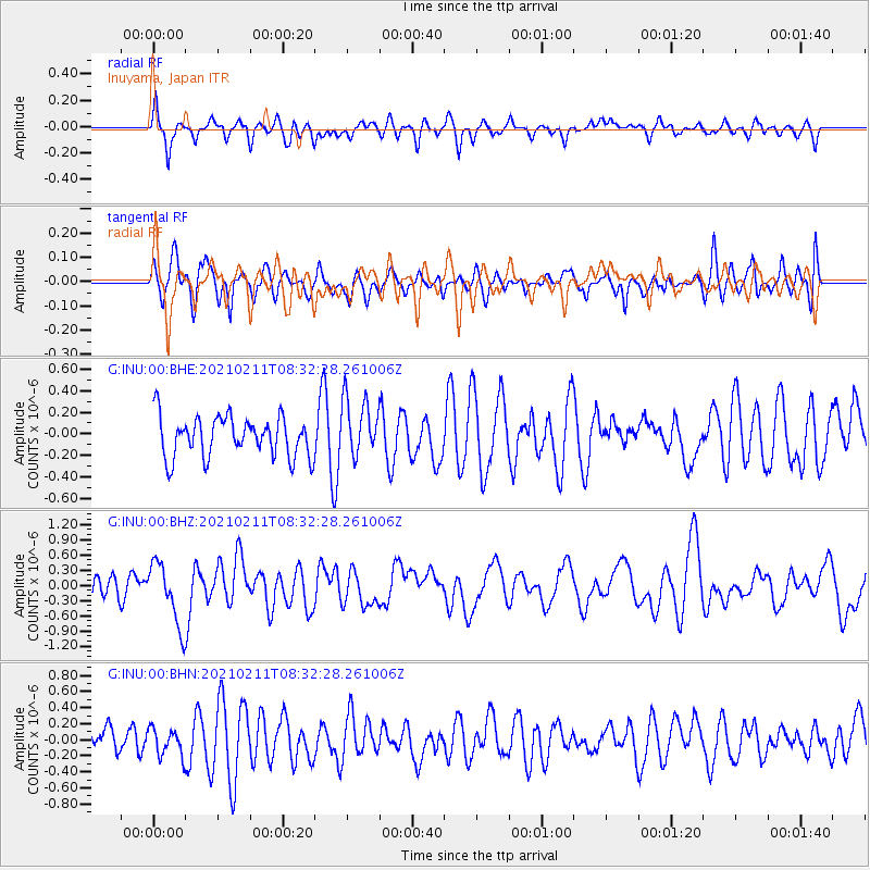
INU Inuyama, Japan - Earthquake Result Viewer
*The percent match for this event was below the threshold and hence no stack was calculated.
| Earthquake location: |
Southeast Of Loyalty Islands |
| Earthquake latitude/longitude: |
-22.9/171.2 |
| Earthquake time(UTC): |
2021/02/11 (042) 08:22:10 GMT |
| Earthquake Depth: |
10 km |
| Earthquake Magnitude: |
5.9 mww |
| Earthquake Catalog/Contributor: |
NEIC PDE/us |
|
| Network: |
G GEOSCOPE |
| Station: |
INU Inuyama, Japan |
| Lat/Lon: |
35.35 N/137.03 E |
| Elevation: |
132 m |
|
| Distance: |
66.4 deg |
| Az: |
329.884 deg |
| Baz: |
145.517 deg |
| Ray Param: |
$rayparam |
*The percent match for this event was below the threshold and hence was not used in the summary stack. |
|
| Radial Match: |
54.01496 % |
| Radial Bump: |
400 |
| Transverse Match: |
50.5942 % |
| Transverse Bump: |
400 |
| SOD ConfigId: |
23341671 |
| Insert Time: |
2021-02-25 09:29:50.287 +0000 |
| GWidth: |
2.5 |
| Max Bumps: |
400 |
| Tol: |
0.001 |
|
Signal To Noise
| Channel | StoN | STA | LTA |
| G:INU:00:BHZ:20210211T08:32:28.261006Z | 2.6131365 | 6.0937094E-7 | 2.3319521E-7 |
| G:INU:00:BHN:20210211T08:32:28.261006Z | 1.2758405 | 1.6760065E-7 | 1.3136489E-7 |
| G:INU:00:BHE:20210211T08:32:28.261006Z | 1.4324149 | 2.6788754E-7 | 1.8701814E-7 |
| Arrivals |
| Ps | |
| PpPs | |
| PsPs/PpSs | |


